
Appalachian Trail in the Smokies Itinerary, Day by Day
The Appalachian Trail follows the crest of the Great Smoky Mountains for about 71 miles, along the state line between Tennessee and North Carolina, from Davenport Gap in the northeast to Fontana Dam in the southwest. The trail climbs over Kuwohi, formerly called Clingmans Dome, which at 6,643 feet is the highest point on the entire Appalachian Trail. Every night in the park is spent at a shelter or campsite on a reservation. The plan below walks the trail southbound in seven days, shelter to shelter.
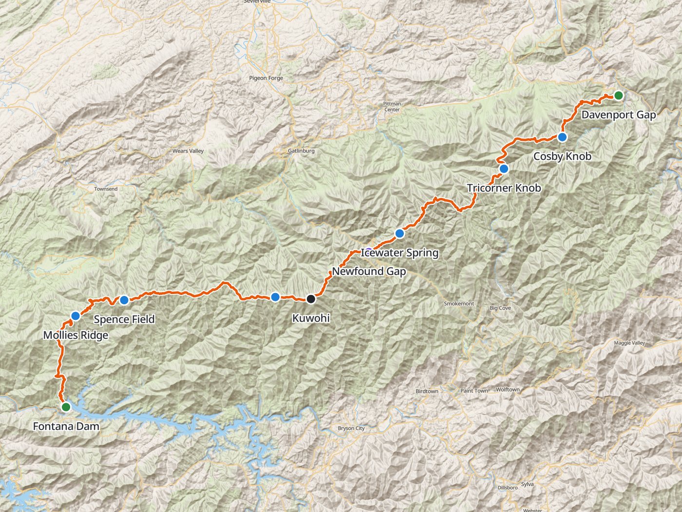
The southbound route with the six shelters of the plan below. Map data © OpenStreetMap contributors, elevation from Copernicus GLO-30.
Take the plan with you
The same six-night plan opens in Backpackers Friend as a ready-made trip, with every shelter and both trailheads already placed, and the app routes between them along the trail. On a computer, scan the code with your phone's camera. On a phone, tap the button instead. With Premium, download the map before you leave and the route works in airplane mode. The GPX file carries the same route and waypoints for any other mapping tool.
The GPX route comes from OpenStreetMap data under the Open Database License.
The six-night plan, southbound
Mileages are measured along the trail line. Climbing and camp elevations come from a 30-meter elevation model sampled along the trail, so treat them as close estimates rather than survey numbers.
| Day | Route | Miles | Climb | Descent | Camp |
|---|---|---|---|---|---|
| 1 | Davenport Gap to Cosby Knob Shelter | 7.9 | 3,900 ft | 1,150 ft | 4,800 ft |
| 2 | Cosby Knob Shelter to Tricorner Knob Shelter | 7.4 | 2,300 ft | 1,100 ft | 6,000 ft |
| 3 | Tricorner Knob Shelter to Icewater Spring Shelter | 12.5 | 2,700 ft | 2,800 ft | 5,900 ft |
| 4 | Icewater Spring Shelter to Double Spring Gap Shelter | 13.3 | 2,650 ft | 3,050 ft | 5,500 ft |
| 5 | Double Spring Gap Shelter to Spence Field Shelter | 13.3 | 2,750 ft | 3,350 ft | 4,900 ft |
| 6 | Spence Field Shelter to Mollies Ridge Shelter | 6.1 | 900 ft | 1,250 ft | 4,600 ft |
| 7 | Mollies Ridge Shelter to Fontana Dam | 10.6 | 1,300 ft | 4,300 ft |
Elevation along the Appalachian Trail through the Smokies. Blue dots mark the six shelters, and the larger dot marks Kuwohi.
Day 1. Davenport Gap to Cosby Knob Shelter, 7.9 miles
The trail leaves Davenport Gap near 2,000 feet and climbs about 3,900 feet onto the main crest, the hardest climb of the trip on the first morning. Cosby Knob Shelter sits just below the crest at mile 7.9.
Day 2. Cosby Knob Shelter to Tricorner Knob Shelter, 7.4 miles
The trail follows the high crest southwest through spruce and fir to Tricorner Knob Shelter at mile 15.3, near where the Balsam Mountain ridge joins the main divide.
Day 3. Tricorner Knob Shelter to Icewater Spring Shelter, 12.5 miles
The route continues along the crest past Pecks Corner at mile 20.6 and along the narrow, exposed ridges above the Tennessee side to Icewater Spring Shelter at mile 27.8.
Day 4. Icewater Spring Shelter to Double Spring Gap Shelter, 13.3 miles
The trail descends to Newfound Gap and U.S. 441 at mile 30.9, the one road crossing in the middle of the park, then climbs steadily to the summit of Kuwohi at mile 38.3, the highest point on the Appalachian Trail. Double Spring Gap Shelter lies a few miles beyond, at mile 41.1.
Day 5. Double Spring Gap Shelter to Spence Field Shelter, 13.3 miles
The trail rolls west along the crest past Derrick Knob Shelter at mile 48.2 to Spence Field, an open grassy bald, and the shelter at mile 54.4.
Day 6. Spence Field Shelter to Mollies Ridge Shelter, 6.1 miles
A short day passes Russell Field Shelter at mile 57.3 and reaches Mollies Ridge Shelter at mile 60.5.
Day 7. Mollies Ridge Shelter to Fontana Dam, 10.6 miles
The last day descends about 4,300 feet off the crest past Birch Spring Gap to Fontana Dam at mile 71.1, near 1,600 feet.
Five nights for stronger legs
Five nights skip Cosby Knob and climb straight to Tricorner Knob on the first day, a 15.3-mile day with about 6,200 feet of climbing.
| Day | Route | Miles | Climb | Descent |
|---|---|---|---|---|
| 1 | Davenport Gap to Tricorner Knob Shelter | 15.3 | 6,200 ft | 2,250 ft |
| 2 | Tricorner Knob Shelter to Icewater Spring Shelter | 12.5 | 2,700 ft | 2,800 ft |
| 3 | Icewater Spring Shelter to Double Spring Gap Shelter | 13.3 | 2,650 ft | 3,050 ft |
| 4 | Double Spring Gap Shelter to Spence Field Shelter | 13.3 | 2,750 ft | 3,350 ft |
| 5 | Spence Field Shelter to Mollies Ridge Shelter | 6.1 | 900 ft | 1,250 ft |
| 6 | Mollies Ridge Shelter to Fontana Dam | 10.6 | 1,300 ft | 4,300 ft |
Permits
- All backcountry camping needs a permit and a reservation. The park moved new bookings to Recreation.gov on April 30, 2026.
- Fees are a $6 permit fee plus $8 per person per night.
- The A.T. thru-hiker permit, which costs $44.50, is only for hikers who start and finish at least 50 miles outside the park and walk only the Appalachian Trail inside the park. A section hike from Davenport Gap to Fontana Dam uses a regular backcountry permit instead.
- Carry a printed copy of the permit while staying overnight in the backcountry.
Rules on the trail
- Sleep inside the shelter. Backpackers whose itineraries include shelters must stay inside the shelter, while thru-hiker permit holders may tent outside if the shelter is full. Hammocks may not be hung inside or from a shelter.
- No consecutive nights at any shelter or at campsite 113, and no more than three nights in a row at any campsite.
- Hang all food and scented items, trash included, on the bear cables at each shelter and campsite.
- Parties are limited to eight people, and two parties from one group may not share a site on the same night.
- Fires are allowed only in the rings at designated sites and shelters, using dead and down wood or certified heat-treated firewood.
- Pets are not allowed on park trails, and wildlife must be given at least 50 yards.
Getting to the trailheads
Davenport Gap sits on the park's northeast edge near Interstate 40, and Fontana Dam sits on the park's southwest corner, a long drive apart, so plan a shuttle or a second car. Any vehicle parked in the park for more than 15 minutes needs a physical parking tag, sold for $5 a day or $15 a week on Recreation.gov and at park kiosks, and a backcountry permit does not exempt you.
Water
Springs near the shelters supply water along the crest, and the park asks hikers to keep soap out of every water source. Treat all of the water.
Questions people ask
How long is the Appalachian Trail in the Smokies?
Measured along the trail line, the Appalachian Trail runs about 71 miles through Great Smoky Mountains National Park from Davenport Gap to Fontana Dam.
Do you have to stay in the shelters on the AT in the Smokies?
If your itinerary includes a shelter, you must sleep inside the shelter. Only A.T. thru-hiker permit holders may tent outside, and only when the shelter is full.
How do you get a backcountry permit for the Smokies?
Reserve a backcountry permit and your shelters on Recreation.gov, where the park moved bookings on April 30, 2026. Fees are $6 per permit plus $8 per person per night.
What is the highest point on the Appalachian Trail?
Kuwohi, formerly called Clingmans Dome, at 6,643 feet in Great Smoky Mountains National Park is the highest point on the entire Appalachian Trail.
Do you need a parking tag for a backcountry trip in the Smokies?
Yes. Any vehicle parked for more than 15 minutes needs a physical parking tag, and a backcountry permit does not exempt you.
Sources
Permits, fees, shelter rules, group size, food storage, fires, and pets come from Great Smoky Mountains National Park's backcountry camping page, updated April 30, 2026. Parking tags come from the park's fees and passes page. Rules change between seasons, so confirm each one with the park before you go.
Plan the trip, then walk the plan
Backpackers Friend opens this plan as a trip on your phone, snaps the route to the trail, and lays the days out on a topo map. Planning is free with no account. Premium adds offline maps so the whole route works in airplane mode, plus off-trail alerts if you drift from the line.
