
Big Pine Lakes and Palisade Glacier Itinerary, Day by Day
The North Fork of Big Pine Creek climbs from the desert edge of the Owens Valley into a chain of glacier-fed lakes below the Palisade Crest. Glacial flour carried down from the Palisade Glacier, which the Forest Service calls the largest glacier in the Sierra, turns the lakes a milky turquoise, and the dark wall of Temple Crag rises directly above them. The plan below camps two nights at Third Lake and spends the middle day climbing past Sam Mack Meadow to a moraine overlook of the glacier.
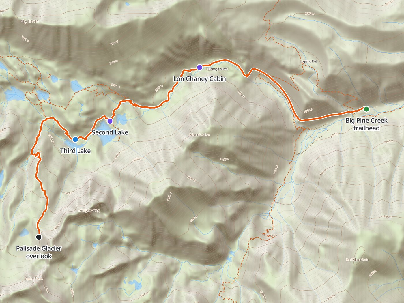
The route up the North Fork, with the camp at Third Lake. Map data © OpenStreetMap contributors, elevation from Copernicus GLO-30.
Take the plan with you
The same two-night plan opens in Backpackers Friend as a ready-made trip, with the camp, the glacier overlook, and the trailhead already placed, and the app routes between them along the trail. The app's Trail Library lists this route as the Palisades Traverse. On a computer, scan the code with your phone's camera. On a phone, tap the button instead. With Premium, download the map before you leave and the route works in airplane mode. The GPX file carries the same route and waypoints for any other mapping tool.
The GPX route comes from OpenStreetMap data under the Open Database License.
The two-night plan
Mileages are measured along the trail line. Climbing and camp elevations come from a 30-meter elevation model sampled along the trail, so treat them as close estimates rather than survey numbers.
| Day | Route | Miles | Climb | Descent | Camp |
|---|---|---|---|---|---|
| 1 | Big Pine Creek trailhead to Third Lake | 5.5 | 2,650 ft | 50 ft | 10,300 ft |
| 2 | Third Lake to the Palisade Glacier overlook and back | 5.7 | 2,200 ft | 2,200 ft | 10,300 ft |
| 3 | Third Lake to the trailhead | 5.5 | 100 ft | 2,650 ft |
Elevation along the route. The blue dot marks the camp at Third Lake, and the larger dot marks the glacier overlook.
Day 1. Trailhead to Third Lake, 5.5 miles
The trail zigzags up a slope of sagebrush, manzanita, and Jeffrey pine past Second Falls, then follows the creek into lodgepole forest and past a stone cabin built by the actor Lon Chaney at mile 2.8. A junction offers a side route past Black Lake with views of the glacier, which rejoins the main trail near Fourth Lake. The main trail passes First Lake at mile 4.6 and Second Lake at mile 4.8 and reaches Third Lake, directly below Temple Crag, at mile 5.5. Camp at least 100 feet from the trail and the water.
Day 2. The Palisade Glacier and back, 5.7 miles
About half a mile above Third Lake, a trail turns south and switchbacks over grassy benches and boulders to Sam Mack Meadow at mile 6.8. Beyond the meadow the route climbs a moraine to an overlook of the Palisade Glacier at mile 8.3. The Forest Service describes the last half mile to the glacier as boulder hopping on a very faint trail, and advises staying on the gently sloping lower glacier unless you are experienced on ice and snow. Return to Third Lake for the second night.
Day 3. Third Lake to the trailhead, 5.5 miles
The walk out descends the same trail past the lakes and the Lon Chaney Cabin, losing about 2,650 feet to the trailhead.
One night at Sam Mack Meadow
One night at Sam Mack Meadow puts camp a short climb below the glacier, at the cost of a longer first day and a long walk out.
| Day | Route | Miles | Climb | Descent |
|---|---|---|---|---|
| 1 | Big Pine Creek trailhead to Sam Mack Meadow | 6.8 | 3,500 ft | 150 ft |
| 2 | Sam Mack Meadow to Big Pine Creek trailhead (finish) | 9.9 | 1,400 ft | 4,800 ft |
Permits
- Reserve an Inyo National Forest wilderness permit for the North Fork of Big Pine Creek on Recreation.gov. The trail allows 25 overnight visitors a day from May 1 to November 1, and day hikers need no permit.
- Reservations open in two blocks. Sixty percent of the quota opens six months before the entry date, and the remaining 40 percent opens two weeks before entry at 7:00 AM Pacific.
- Fees are a $6 transaction fee per permit plus $5 per person.
- Print the permit at home up to seven days before the trip. The forest cancels unprinted overnight reservations at 10:00 AM on the entry date.
Rules on the trail
- Campfires are closed in the North and South forks of Big Pine Creek.
- Store food from bears. Inyo allows a counterbalance hang at least 15 feet up and 10 feet from the trunk where trees are suitable, and requires a bear-resistant container where trees are not.
- Groups are limited to 15 people, day users included.
- Camp at least 100 feet from trails and water, on an existing site.
- Pack stock use these trails. Stock have the right of way, so step off the trail and stand quietly until the animals pass.
Getting to the trailhead
The trailhead sits at the end of Glacier Lodge Road, about ten miles west of the town of Big Pine on U.S. 395, where Crocker Street turns west. The Forest Service trail sheet places overnight parking a short walk below the day-use lot at the end of the road.
Water
The North Fork of Big Pine Creek and the lakes supply water the whole way. The Forest Service notes giardia in most of the waters and recommends boiling or filtering, so treat all of the water.
Questions people ask
How far are the Big Pine Lakes from the trailhead?
Measured along the trail line, First Lake sits about 4.6 miles from the trailhead, Second Lake about 4.8 miles, and Third Lake about 5.5 miles, with roughly 2,650 feet of climbing to Third Lake.
Can you hike to the Palisade Glacier?
Yes. A trail leaves the main route about half a mile above Third Lake and climbs to Sam Mack Meadow, and a rough path continues to a moraine overlook of the glacier. The Forest Service describes the last half mile as boulder hopping on a faint trail.
Do you need a permit for the Big Pine Lakes?
Overnight trips need an Inyo National Forest wilderness permit, and the North Fork allows 25 overnight visitors a day from May 1 to November 1. Day hikes need no permit.
Are campfires allowed at the Big Pine Lakes?
No. Inyo National Forest closes campfires in the North and South forks of Big Pine Creek, so cook on a stove.
Why is Second Lake so blue?
The Forest Service explains that fine glacial powder carried down from the Palisade Glacier gives the lakes their milky turquoise color.
Sources
The route description, the glacier approach, and the trailhead directions come from the Forest Service's Big Pine Canyon hiking sheet, and the quota and group size from the forest's North Fork Big Pine Creek trail page. Campfire, food, and camping rules come from Inyo National Forest's wilderness regulations, and permit timing and fees from the wilderness permits page. Rules change between seasons, so confirm each one with the forest before you go.
Plan the trip, then walk the plan
Backpackers Friend opens this plan as a trip on your phone, snaps the route to the trail, and lays the days out on a topo map. Planning is free with no account. Premium adds offline maps so the whole route works in airplane mode, plus off-trail alerts if you drift from the line.
