
Canyon Creek Lakes Itinerary, Day by Day
Canyon Creek is one of the most popular routes into the Trinity Alps, and for good reason. The trail follows the creek for about seven and a half miles past meadows, The Sinks, and Canyon Creek Falls to a pair of lakes set in bare granite high in the range. The Forest Service calls the walk a moderate seven-mile hike. The plan below spends two nights at Lower Canyon Creek Lake, with a short middle day to the upper lake and the slabs around the basin.
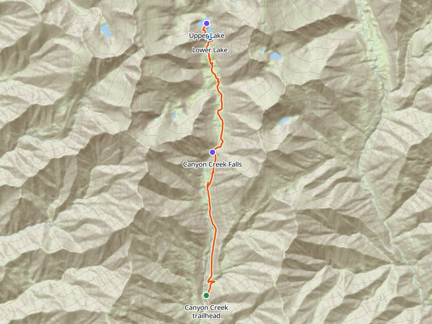
The route up Canyon Creek, with the camp at the lower lake. Map data © OpenStreetMap contributors, elevation from Copernicus GLO-30.
Take the plan with you
The same two-night plan opens in Backpackers Friend as a ready-made trip, with the camp and the trailhead already placed, and the app routes between them along the trail. The app's Trail Library lists this route as the Trinity Alps High Route. On a computer, scan the code with your phone's camera. On a phone, tap the button instead. With Premium, download the map before you leave and the route works in airplane mode. The GPX file carries the same route and waypoints for any other mapping tool.
The GPX route comes from OpenStreetMap data under the Open Database License.
The two-night plan
Mileages are measured along the trail line and agree with the Forest Service figures of about 7.5 miles to the lower lake and 8 miles to the upper lake. Climbing and camp elevations come from a 30-meter elevation model, so treat them as close estimates.
| Day | Route | Miles | Climb | Descent | Camp |
|---|---|---|---|---|---|
| 1 | Canyon Creek trailhead to Lower Canyon Creek Lake | 7.5 | 2,850 ft | 350 ft | 5,700 ft |
| 2 | Lower Lake to Upper Lake and back | 1.0 | 200 ft | 100 ft | 5,700 ft |
| 3 | Lower Canyon Creek Lake to the trailhead | 7.4 | 300 ft | 2,850 ft |
Elevation along the route. The blue dot marks the camp at Lower Canyon Creek Lake.
Day 1. Trailhead to Lower Canyon Creek Lake, 7.5 miles
The trail climbs gradually through forest above Canyon Creek. The Sinks, where the creek runs out of sight beneath granite slabs and forested camps sit off a short spur, comes near mile 3. Canyon Creek Falls follows near mile 4.1, and above the meadows the trail climbs about 2,850 feet in all to Lower Canyon Creek Lake at mile 7.5. Fires are prohibited at the lakes.
Day 2. Upper Canyon Creek Lake and back, 1.0 mile
A short scramble over granite leads to Upper Canyon Creek Lake at mile 8.1. Spend the day on the slabs around the basin and return to the lower lake for the second night.
Day 3. Lower Canyon Creek Lake to the trailhead, 7.4 miles
The walk out descends the same trail past the falls and The Sinks, losing about 2,850 feet to the trailhead.
Three nights with a camp at The Sinks
Three nights add a first camp at The Sinks, which splits the climb and suits a late start from the trailhead.
| Day | Route | Miles | Climb | Descent |
|---|---|---|---|---|
| 1 | Canyon Creek trailhead to The Sinks | 3.0 | 1,100 ft | 250 ft |
| 2 | The Sinks to Lower Canyon Creek Lake | 4.5 | 1,750 ft | 100 ft |
| 3 | Lower Lake to Upper Lake and back | 1.0 | 200 ft | 100 ft |
| 4 | Lower Canyon Creek Lake to the trailhead | 7.4 | 300 ft | 2,850 ft |
Permits
- Overnight stays need two free permits. The forest requires both a wilderness permit and a campfire permit to stay overnight in the Trinity Alps Wilderness, and day hikes need no permit.
- Pick up the wilderness permit at a kiosk outside the Weaverville Ranger Station, the Redding Supervisor's Office, the Shasta Lake Ranger Station, or one of several fire stations.
- Get the campfire permit online or at the same offices. California requires the permit for stoves as well as fires.
Rules on the trail
- Carry a bear canister. The forest requires canisters in the Canyon Creek area because of rising bear conflicts there.
- Campfires are prohibited at the lakes.
- Groups are limited to 10 people.
- Travel is on foot or horseback. Bicycles, drones, motorized vehicles, and other mechanized equipment are not allowed in the wilderness.
- The current restrictions order runs through September 19, 2028. Check the forest's alerts page for changes.
Getting to the trailhead
The trailhead sits at the end of Canyon Creek Road, which leaves California Highway 299 at Junction City west of Weaverville. The Weaverville Ranger Station, at 360 Main Street, sells maps and answers questions about current conditions.
Water
Canyon Creek runs beside the trail most of the way, and both lakes supply water at camp. Treat all of the water.
Questions people ask
How long is the hike to the Canyon Creek Lakes?
The Forest Service lists Lower Canyon Creek Lake at about 7.5 miles and the upper lake at about 8 miles from the trailhead. Measured along the trail line, the round trip with a visit to the upper lake runs about 15.9 miles.
Do you need a permit for the Canyon Creek Lakes?
Overnight trips need a free wilderness permit from a Forest Service kiosk and a free California campfire permit, which also covers stoves. Day hikes need no permit.
Do you need a bear canister in Canyon Creek?
Yes. The Shasta-Trinity National Forest requires bear canisters in the Canyon Creek area.
Can you have a campfire at the Canyon Creek Lakes?
No. Campfires are prohibited at the lakes.
Sources
Permits, the canister rule, the fire ban at the lakes, group size, and the trail description come from the Shasta-Trinity National Forest's Canyon Creek trail page. Lake distances come from the forest's Trinity Alps trail and lake information, and the restrictions order from the forest's Trinity Alps Wilderness restrictions alert. Rules change between seasons, so confirm each one with the forest before you go.
Plan the trip, then walk the plan
Backpackers Friend opens this plan as a trip on your phone, snaps the route to the trail, and lays the days out on a topo map. Planning is free with no account. Premium adds offline maps so the whole route works in airplane mode, plus off-trail alerts if you drift from the line.
