
Grand Canyon Rim-to-Rim Backpacking Itinerary, Day by Day
Crossing the Grand Canyon rim to rim drops more than a mile from the forested North Rim to the Colorado River and climbs nearly as far back out to the South Rim. The classic crossing follows the North Kaibab Trail down Bright Angel Canyon past Cottonwood Campground to the river and climbs the Bright Angel Trail past Havasupai Gardens to the South Rim, about 23 miles in all. The plan below walks the crossing in three days with nights at the two corridor campgrounds, for a future season when the North Kaibab is open.
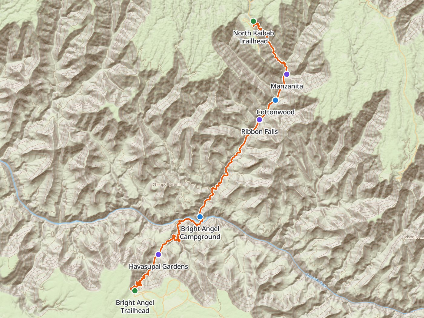
The crossing from north to south, with the two camps of the plan below. Map data © OpenStreetMap contributors, elevation from Copernicus GLO-30.
Take the plan with you
The same two-night plan opens in Backpackers Friend as a ready-made trip, with both campgrounds and both trailheads already placed, and the app routes between them along the trail. On a computer, scan the code with your phone's camera. On a phone, tap the button instead. With Premium, download the map before you leave and the route works in airplane mode. The GPX file carries the same route and waypoints for any other mapping tool.
The GPX route comes from OpenStreetMap data under the Open Database License.
The two-night plan, north to south
Mileages are measured along the trail line. Climbing and camp elevations come from a 30-meter elevation model sampled along the trail, so treat them as close estimates rather than survey numbers.
| Day | Route | Miles | Climb | Descent | Camp |
|---|---|---|---|---|---|
| 1 | North Kaibab Trailhead to Cottonwood Campground | 6.6 | 500 ft | 4,600 ft | 4,100 ft |
| 2 | Cottonwood Campground to Bright Angel Campground | 7.3 | 1,000 ft | 2,500 ft | 2,600 ft |
| 3 | Bright Angel Campground to Bright Angel Trailhead | 9.4 | 5,150 ft | 950 ft |
Elevation across the canyon. Blue dots mark Cottonwood Campground and Bright Angel Campground.
Day 1. North Kaibab Trailhead to Cottonwood Campground, 6.6 miles
The North Kaibab Trail drops steeply from the forest of the North Rim through Supai Tunnel at mile 1.7 and down Roaring Springs Canyon to the Manzanita Rest Area at mile 5.2. Cottonwood Campground sits a mile and a half beyond, at mile 6.6. The day loses about 4,600 feet, which punishes the knees far more than the lungs.
Day 2. Cottonwood Campground to Bright Angel Campground, 7.3 miles
The trail follows Bright Angel Creek downstream. A short side trail near mile 7.8 leads to Ribbon Falls. Below, the canyon narrows through the dark rock of the inner gorge to Phantom Ranch and Bright Angel Campground beside the Colorado River at mile 13.9. The inner canyon runs very hot in summer, so walk in the early morning.
Day 3. Bright Angel Campground to the South Rim, 9.4 miles
The route crosses the Colorado River on a footbridge and climbs the Bright Angel Trail past Havasupai Gardens at mile 18.5 to the Bright Angel Trailhead on the South Rim at mile 23.3, a climb of more than 5,000 feet. Start before dawn to climb in the shade.
Three nights with a stop at Havasupai Gardens
Three nights add a camp at Havasupai Gardens and split the long climb to the South Rim into two shorter days.
| Day | Route | Miles | Climb | Descent |
|---|---|---|---|---|
| 1 | North Kaibab Trailhead to Cottonwood Campground | 6.6 | 500 ft | 4,600 ft |
| 2 | Cottonwood Campground to Bright Angel Campground | 7.3 | 1,000 ft | 2,500 ft |
| 3 | Bright Angel Campground to Havasupai Gardens | 4.6 | 1,750 ft | 550 ft |
| 4 | Havasupai Gardens to Bright Angel Trailhead | 4.8 | 3,400 ft | 400 ft |
Permits
- Overnight trips below the rim need a backcountry permit. Day hikes do not.
- Enter the early access lottery on Recreation.gov. Applications open for two weeks and close at 5:00 PM Mountain Standard Time on the first of the month, four months before your start month. Up to 750 applicants receive a time slot to reserve an itinerary.
- Remaining space opens to everyone on the first of the following month, and trips starting within three months can be booked through the availability calendar.
- Fees are $10 per permit or lottery application plus $15 per person per night below the rim.
- Groups are limited to 11 people, and small groups of one to six have more permits available.
Rules on the trail
- Corridor campgrounds allow two nights per campground per hike, consecutive or not. From November 15 through February 28 the limit rises to four nights.
- Phantom Ranch lodging needs a lodge reservation rather than a backcountry permit, and the lodge is closed as of October 2026.
- Organized groups of 12 to 30 need a special use permit even for a rim-to-rim day hike.
When to go
The North Rim season runs from May 15 to October 15, when the North Rim campground and services operate. Overnight camping on the North Rim outside that season needs a backcountry permit, and the gate on State Route 67 closes for winter at the end of November or with the first big snowstorm. Summer heat in the inner canyon is the greatest danger on the crossing, so spring and autumn trips are the most comfortable.
Water
Water along the corridor depends on the season and the state of the park's water system. The North Rim has no drinking water at all in 2026, and the park lists current water availability on the park's key hiking messages page. Carry enough to reach each confirmed source, and treat any water taken from the creek or the river.
Questions people ask
How long is the Grand Canyon rim-to-rim hike?
Measured along the trail line, the crossing from the North Kaibab Trailhead to the Bright Angel Trailhead runs about 23.3 miles, with roughly 5,800 feet of descent to the river and more than 4,000 feet of climbing to the South Rim.
Is the North Kaibab Trail open?
Not as of October 2026. The park reports that the North Kaibab Trail closed on August 29, 2026 after a flash flood. Check the park's trail status before you plan a crossing.
How do you get a Grand Canyon backcountry permit?
Enter the early access lottery on Recreation.gov, which closes at 5:00 PM Mountain Standard Time on the first of the month four months before your start month. Remaining space opens to everyone on the first of the following month.
How many nights can you stay at Bright Angel Campground?
Corridor campgrounds allow two nights per campground per hike, or four nights from November 15 through February 28.
When is the North Rim open?
The North Rim season runs from May 15 to October 15. The rim reopened on May 15, 2026 with reduced services after the 2025 Dragon Bravo Fire.
Sources
Current closures and North Rim services come from Grand Canyon's operations update, updated October 11, 2026, and the North Rim reopening from the park's 2026 North Rim season announcement. Permits, fees, group size, and camping limits come from the park's backcountry permit page. Rules and closures change quickly in the canyon, so confirm each one with the park before you go.
Plan the trip, then walk the plan
Backpackers Friend opens this plan as a trip on your phone, snaps the route to the trail, and lays the days out on a topo map. Planning is free with no account. Premium adds offline maps so the whole route works in airplane mode, plus off-trail alerts if you drift from the line.
