
Half Dome Backpacking Itinerary, Day by Day
Half Dome rises 8,800 feet above sea level and nearly a mile above the floor of Yosemite Valley. Most people climb the dome in one very long day, and the park says most day hikers need 10 to 12 hours. Backpacking the route splits that effort in two. The plan below climbs the Mist Trail past Vernal and Nevada falls to a camp in Little Yosemite Valley, climbs the cables early the next morning before the crowds and the afternoon storms, and returns to Happy Isles by the John Muir Trail.
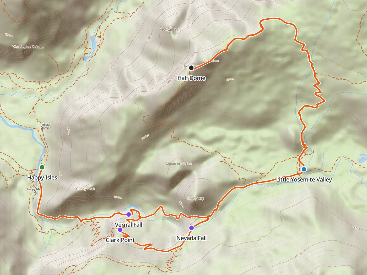
The route from Happy Isles, with the camp in Little Yosemite Valley. Map data © OpenStreetMap contributors, elevation from Copernicus GLO-30.
Take the plan with you
The same plan opens in Backpackers Friend as a ready-made trip, with the trailhead and the camp already placed, and the app routes between them along the trail. On a computer, scan the code with your phone's camera. On a phone, tap the button instead. With Premium, download the map before you leave and the route works in airplane mode. The GPX file carries the same route and waypoints for any other mapping tool.
The GPX route comes from OpenStreetMap data under the Open Database License.
The one-night plan
Mileages are measured along the trail line, which the park describes as a 14- to 16-mile round trip. Climbing and camp elevations come from a 30-meter elevation model, which rounds the summit off, so treat them as close estimates.
| Day | Route | Miles | Climb | Descent | Camp |
|---|---|---|---|---|---|
| 1 | Happy Isles trailhead to Little Yosemite Valley campground | 4.2 | 2,300 ft | 200 ft | 6,200 ft |
| 2 | Little Yosemite Valley to the summit and back to Happy Isles | 11.5 | 2,650 ft | 4,750 ft |
Elevation along the route. The blue dot marks the camp in Little Yosemite Valley, and the larger dot marks the summit of Half Dome.
Day 1. Happy Isles to Little Yosemite Valley, 4.2 miles
The trail climbs the Mist Trail, a long granite staircase beside Vernal Fall that stays wet with spray, to the top of the fall at mile 1.4. The route continues past Emerald Pool to the top of Nevada Fall at mile 2.8 and levels out into Little Yosemite Valley. Camping between Happy Isles and Glacier Point is restricted to the Little Yosemite Valley campground, where fires are allowed only in the communal rings. Food lockers stand in the campground, and the park requires a bear canister everywhere else in the wilderness.
Day 2. Half Dome and back to Happy Isles, 11.5 miles
Leave camp at first light. The trail climbs about 2,300 feet through forest to the shoulder of the dome and up a steep granite stairway onto the subdome, where the cables begin. The park names wet rock and wet cables as the leading cause of fatal falls on the route, and warns that the summit is a dangerous place in a lightning storm, so stay off the cables in rain and turn back at the first sign of thunder. From the summit the route returns to camp and descends the John Muir Trail past Clark Point to Happy Isles, a gentler path than the Mist Trail on tired legs.
Two nights for a slower summit day
Two nights in Little Yosemite Valley turn the summit into a 7-mile round trip from camp, with a short walk out on the third morning.
| Day | Route | Miles | Climb | Descent |
|---|---|---|---|---|
| 1 | Happy Isles trailhead to Little Yosemite Valley campground | 4.2 | 2,300 ft | 200 ft |
| 2 | Little Yosemite Valley to the summit and back | 7.0 | 2,450 ft | 2,450 ft |
| 3 | Little Yosemite Valley to Happy Isles | 4.5 | 200 ft | 2,300 ft |
Permits
- Reserve a Yosemite wilderness permit for the Happy Isles to Little Yosemite Valley trailhead. The park awards 60 percent of each trailhead's quota through a weekly lottery 24 weeks before the entry date and releases the other 40 percent seven days ahead.
- Wilderness permit fees are $10 per application and $5 per person on a confirmed permit.
- Add the Half Dome permit at pickup. A wilderness permit alone does not cover the cables. Backpackers starting from a qualifying Yosemite trailhead can add Half Dome permits for some or all of the group when they pick up the wilderness permit, for $10 per person, with no advance reservation.
- Permits from outside the park do not count. Yosemite does not accept a wilderness permit issued elsewhere for Half Dome, and backpackers starting outside the park must enter the Half Dome lotteries.
Rules on the trail
- Camp only in the Little Yosemite Valley campground between Happy Isles and Glacier Point.
- Carry a bear canister. Yosemite requires canisters throughout the wilderness and prohibits hanging food.
- Fires are allowed only in the communal rings in Little Yosemite Valley and are prohibited on top of Half Dome.
- Groups are limited to 15 people. Pets, wheeled vehicles, and drones are prohibited in the wilderness.
When to go
Half Dome permits are required seven days a week while the cables are up. The park usually raises the cables on the Friday before Memorial Day and lowers them the day after the second Monday in October, and the dates shift with conditions. Summer afternoons bring thunderstorms over the high country, which is the strongest reason to camp in Little Yosemite Valley and climb the cables in the morning.
Water
The Merced River runs beside the Mist Trail and through Little Yosemite Valley, so water is easy on the first day. The climb from Little Yosemite Valley to the summit has no reliable water, so carry enough for the round trip from camp. Treat all of the water.
Questions people ask
How long is the hike to Half Dome?
The park describes the round trip from Happy Isles as 14 to 16 miles with about 4,800 feet of climbing. This route, up the Mist Trail and down the John Muir Trail, measures 15.7 miles.
Can you backpack to Half Dome?
Yes. Backpackers camp in the Little Yosemite Valley campground with a Yosemite wilderness permit, which splits the trip into a short first day and a summit day.
How do backpackers get a Half Dome permit?
Backpackers starting from a qualifying Yosemite trailhead, such as Happy Isles to Little Yosemite Valley, can add Half Dome permits for their group when they pick up the wilderness permit, for $10 per person.
When are the Half Dome cables up?
The park usually raises the cables on the Friday before Memorial Day and lowers them the day after the second Monday in October, with dates subject to conditions.
What time should you turn around on Half Dome?
The park advises turning around if you have not reached the summit by 3:30 PM, and staying off the cables whenever the rock or the cables are wet.
Sources
Distance, climbing, the cable season, hazards, and the turnaround time come from Yosemite's Half Dome page, and the backpacker permit rules from the park's Half Dome permits for backpackers page. The lottery schedule and fees come from the wilderness permits page, and camping, fire, and food rules from the wilderness regulations. Rules change between seasons, so confirm each one with the park before you go.
Plan the trip, then walk the plan
Backpackers Friend opens this plan as a trip on your phone, snaps the route to the trail, and lays the days out on a topo map. Planning is free with no account. Premium adds offline maps so the whole route works in airplane mode, plus off-trail alerts if you drift from the line.
