
High Sierra Trail Itinerary, Day by Day
The High Sierra Trail crosses the southern Sierra from west to east. The route leaves the Giant Forest at Crescent Meadow, traverses high above the Middle Fork of the Kaweah River to Bearpaw Meadow, climbs past Hamilton Lakes and Precipice Lake to 10,700-foot Kaweah Gap, drops into the deep trough of the Kern Canyon, and climbs to the summit of Mount Whitney before descending to Whitney Portal. The National Park Service measures the full route at 72.2 miles. The plan below follows the park's suggested six days.
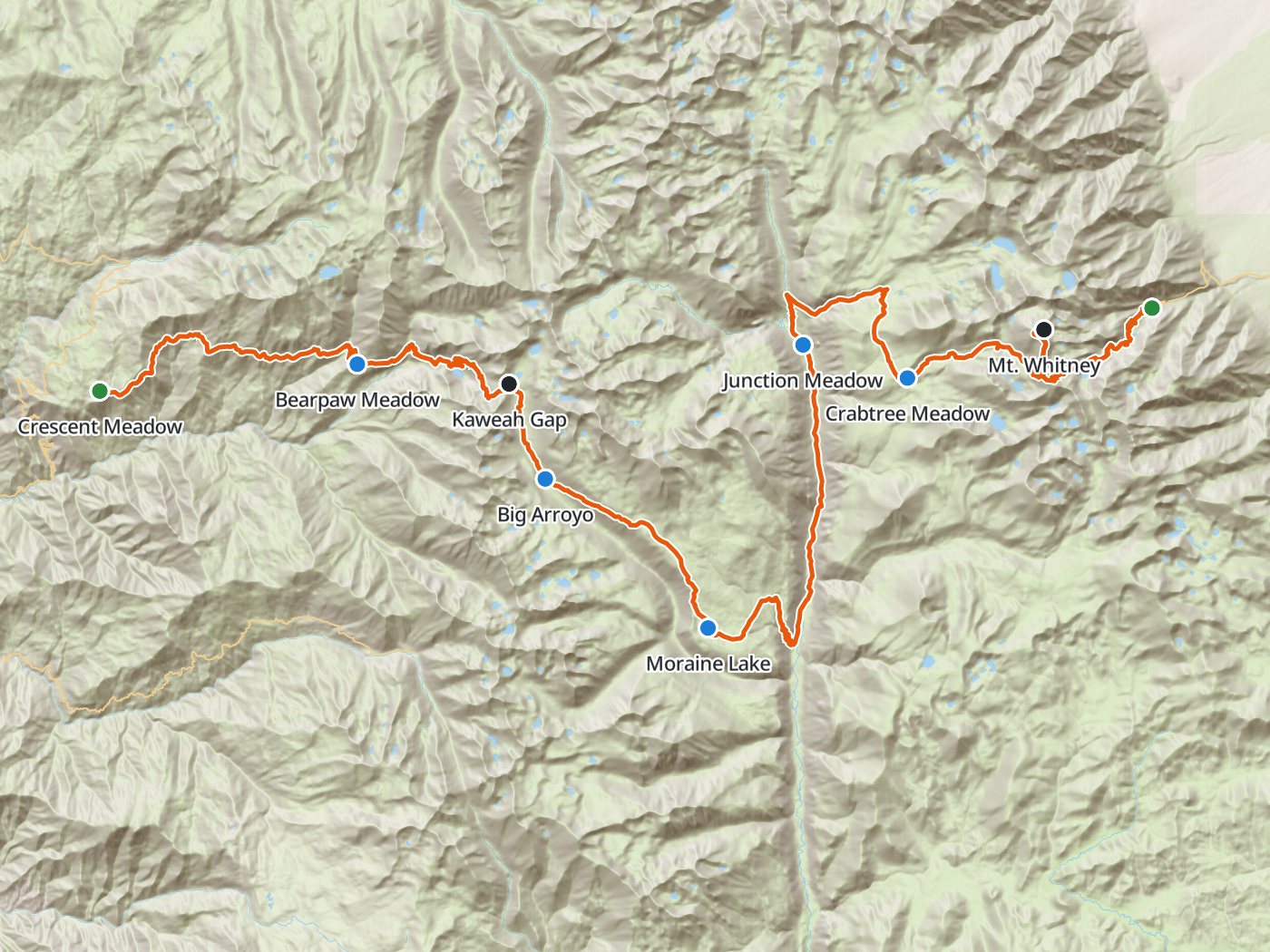
The route with the five camps of the plan below. Map data © OpenStreetMap contributors, elevation from Copernicus GLO-30.
Take the plan with you
The same five-night plan opens in Backpackers Friend as a ready-made trip, with every camp, Kaweah Gap, the summit, and both trailheads already placed, and the app routes between them along the trail. On a computer, scan the code with your phone's camera. On a phone, tap the button instead. With Premium, download the map before you leave and the route works in airplane mode. The GPX file carries the same route and waypoints for any other mapping tool.
The GPX route comes from OpenStreetMap data under the Open Database License.
The five-night plan, west to east
The days follow the park's own suggested itinerary, and the mileages are the park's published figures. Climbing and camp elevations come from a 30-meter elevation model sampled along the trail, so treat them as close estimates rather than survey numbers.
| Day | Route | Miles | Climb | Descent | Camp |
|---|---|---|---|---|---|
| 1 | Crescent Meadow trailhead to Bearpaw Meadow | 11.4 | 3,250 ft | 2,200 ft | 7,800 ft |
| 2 | Bearpaw Meadow to Big Arroyo Junction | 11.1 | 4,400 ft | 2,600 ft | 9,600 ft |
| 3 | Big Arroyo Junction to Moraine Lake | 8.0 | 1,200 ft | 1,450 ft | 9,300 ft |
| 4 | Moraine Lake to Junction Meadow | 13.7 | 1,500 ft | 2,750 ft | 8,100 ft |
| 5 | Junction Meadow to Crabtree Meadow | 8.9 | 3,250 ft | 550 ft | 10,700 ft |
| 6 | Crabtree Meadow to Whitney Portal | 19.1 | 4,450 ft | 6,800 ft |
Elevation along the High Sierra Trail. Blue dots mark the five camps, and the larger dots mark Kaweah Gap and the summit of Mount Whitney.
Day 1. Crescent Meadow to Bearpaw Meadow, 11.4 miles
The trail leaves Crescent Meadow and contours along the north wall of the Middle Fork Kaweah canyon, with the Great Western Divide ahead for most of the day. Nine Mile Creek comes at mile 8.8, and Bearpaw Meadow at mile 11.4. Camping at Bearpaw Meadow is limited to designated sites. The Bearpaw Meadow Camp nearby is a tent hotel run by the park concessionaire, and staying there requires a reservation.
Day 2. Bearpaw Meadow over Kaweah Gap to Big Arroyo, 11.1 miles
The trail crosses Lone Pine Creek at mile 13.1 and climbs to Big Hamilton Lake at mile 16.6. The park allows one night at most at Hamilton Lakes and prohibits fires in the Hamilton Lakes basin. Above the lake the trail climbs a long series of switchbacks past Precipice Lake, which often stays frozen into midsummer, to Kaweah Gap at 10,700 feet. The far side drops into the Big Arroyo, and the camp at Big Arroyo Junction sits at mile 22.5. This day carries the most climbing of the first half.
Day 3. Big Arroyo to Moraine Lake, 8.0 miles
The route climbs out of the Big Arroyo onto the Chagoopa Plateau and follows the Moraine Lake trail, which the park's mileage table uses, to Moraine Lake at mile 30.5. The short day leaves time to rest before the descent into the Kern Canyon.
Day 4. Moraine Lake down the Kern Canyon to Junction Meadow, 13.7 miles
Fill every bottle at Sky Parlor Meadow, because the park warns that the stretch beyond runs long and dry. The trail then drops steeply to the Kern River at Upper Funston Meadow, mile 34.5, and turns north up the canyon. Kern Hot Spring comes at mile 36.8, and camping there is limited to designated sites. The canyon floor runs hot and dry at midday, so start early. Junction Meadow, where the trail leaves the Kern, sits at mile 44.2.
Day 5. Junction Meadow to Crabtree Meadow, 8.9 miles
The trail climbs about 3,200 feet up Wallace Creek and joins the John Muir Trail at Wallace Creek, mile 48.9. The combined trail heads south to the ranger station at Crabtree Meadow, mile 53.1. The park allows two nights at most in the Crabtree and Whitney Creek area and at Guitar Lake. Go to bed early, since the next day is the longest of the trip.
Day 6. Over Mount Whitney to Whitney Portal, 19.1 miles
Guitar Lake at mile 56.6 is the last campsite with water before the summit, and the park warns that no reliable water exists between Guitar Lake and Trail Camp on the east side. Above Guitar Lake the trail switchbacks to the junction below Trail Crest, where the summit spur leads to the top of Mount Whitney at 14,505 feet, mile 61.5. The park advises against sheltering in the summit hut during a storm, because the metal roof attracts lightning. From the summit the route returns to Trail Crest and descends past Trail Camp at mile 65.7 and Outpost Camp at mile 68.7 to Whitney Portal at mile 72.2.
Seven nights for an easier pace
Seven nights splits the first big day at Hamilton Lakes, spends a night at Kern Hot Spring, and moves the summit start up to Guitar Lake, so no day runs longer than 16 miles.
| Day | Route | Miles | Climb | Descent |
|---|---|---|---|---|
| 1 | Crescent Meadow trailhead to Bearpaw Meadow | 11.4 | 3,250 ft | 2,200 ft |
| 2 | Bearpaw Meadow to Big Hamilton Lake | 5.2 | 1,800 ft | 1,200 ft |
| 3 | Big Hamilton Lake to Big Arroyo Junction | 5.9 | 2,600 ft | 1,450 ft |
| 4 | Big Arroyo Junction to Moraine Lake | 8.0 | 1,200 ft | 1,450 ft |
| 5 | Moraine Lake to Kern Hot Spring | 6.3 | 250 ft | 2,650 ft |
| 6 | Kern Hot Spring to Wallace Creek | 12.1 | 3,700 ft | 200 ft |
| 7 | Wallace Creek to Guitar Lake | 7.7 | 1,700 ft | 600 ft |
| 8 | Guitar Lake to Whitney Portal | 15.6 | 3,550 ft | 6,650 ft |
Permits
- Every overnight trip needs a wilderness permit from Sequoia and Kings Canyon National Parks. Book the High Sierra Trail entry, because the park requires a High Sierra Trail permit between Seven Mile Hill and Kaweah Gap and does not accept an Alta Trail permit there.
- Reservations open six months before the entry date on Recreation.gov, released daily at 7:00 AM Pacific, and close one week before entry. The quota season ran May 22 to September 26 in 2026.
- A reservation costs $15 per trip plus $5 per person. The per-person fee is refundable for cancellations made at least a week out.
- Pick up the permit between 1:00 PM the day before entry and 10:00 AM on the entry day. The park cancels unclaimed reservations at 10:00 AM unless you call ahead.
- The exit over Trail Crest enters the Mt. Whitney Zone in Inyo National Forest. Inyo accepts a permit issued by Sequoia and Kings Canyon when the trip meets the forest's requirements for continuous wilderness travel.
Rules on the trail
- Carry a bear canister. Sequoia requires one wherever a camp lacks food storage boxes or trees for hanging, and Inyo requires canisters on the Mt. Whitney Trail from Memorial Day weekend to November 1.
- Pack out human waste in the Whitney Zone. Inyo requires pack-out kits there year round and forbids storing used kits in a bear canister.
- Bearpaw Meadow and Kern Hot Spring allow camping only in designated sites.
- Hamilton Lakes allow one night, and Crabtree Meadow and Guitar Lake allow two nights each. Timberline Lake and Mirror Lake are closed to camping.
- Campfires are prohibited above 9,000 feet west of the Great Western Divide, above 10,000 feet east of the divide, throughout the Hamilton Lakes basin, and at any elevation in the Whitney Zone.
- Parties are limited to 15 people on trail. Pets are not allowed on park trails.
Getting to the trailheads
Crescent Meadow sits at the end of a short road beyond the Giant Forest, and the park runs a summer shuttle to the trailhead. Backpackers holding a wilderness permit may drive to Crescent Meadow at any hour, even when the road is closed to other traffic. Whitney Portal sits on the far side of the Sierra above Lone Pine, so plan the ride or the second car before you start, because the drive between the two trailheads goes the long way around the southern end of the range.
When to go
The park warns that creek crossings can be hazardous early in the summer and that Precipice Lake often stays frozen into midsummer, so snow on Kaweah Gap and Trail Crest sets the start of the season. The quota season runs from late May to late September. Afternoon thunderstorms build over the high country in summer, so plan to cross Kaweah Gap and reach the summit of Mount Whitney early in the day. Check current trail conditions with the park when you pick up the permit.
Water
Creeks and lakes supply water at every camp in the plans above. Two stretches need a full load. The park warns that the section past Sky Parlor Meadow on the Chagoopa Plateau runs long and dry, and that no reliable water exists between Guitar Lake and Trail Camp, which covers the whole climb over the summit. Treat all of the water.
Questions people ask
How long is the High Sierra Trail?
The National Park Service measures the High Sierra Trail at 72.2 miles from Crescent Meadow to Whitney Portal, including the summit of Mount Whitney at mile 61.5. Measured from a 30-meter elevation model, the route climbs about 17,900 feet.
How many days does the High Sierra Trail take?
The park suggests six days from Crescent Meadow to Whitney Portal, with nights at Bearpaw Meadow, Big Arroyo, Moraine Lake, Junction Meadow, and Crabtree Meadow. A seven-night plan adds Hamilton Lakes and Kern Hot Spring and starts the summit day from Guitar Lake.
What permit do you need for the High Sierra Trail?
You need a Sequoia and Kings Canyon wilderness permit for the High Sierra Trail entry, reserved on Recreation.gov up to six months before the entry date. Inyo National Forest accepts that permit for the exit over Trail Crest to Whitney Portal when the trip is continuous.
Do you need a bear canister on the High Sierra Trail?
Plan on carrying one. Sequoia requires a canister wherever a camp lacks food storage boxes or trees for hanging, and Inyo National Forest requires canisters on the Mt. Whitney Trail from Memorial Day weekend to November 1.
Can you camp at Kern Hot Spring?
Yes, in designated campsites only. The park notes that those sites see heavy use, so arrive early in the afternoon.
Do you have to pack out human waste on the High Sierra Trail?
Yes, inside the Mt. Whitney Zone. Inyo National Forest requires all human waste to be packed out there in pack-out kits year round, which covers the summit and the descent to Whitney Portal.
Sources
Mileages, the suggested itinerary, designated sites, and seasonal warnings come from the National Park Service's High Sierra Trail page. Camping limits, fire rules, and food storage rules come from the park's minimum impact restrictions, and permit dates and fees from the wilderness permits page. Whitney Zone rules and the exit permit policy come from Inyo National Forest's Mt. Whitney Trail page and wilderness permits page. Rules change between seasons, so confirm each one with the agencies before you go.
Plan the trip, then walk the plan
Backpackers Friend opens this plan as a trip on your phone, snaps the route to the trail, and lays the days out on a topo map. Planning is free with no account. Premium adds offline maps so the whole route works in airplane mode, plus off-trail alerts if you drift from the line.
