
John Muir Trail Itinerary, Day by Day
The John Muir Trail runs 211 miles along the high Sierra Nevada, from Happy Isles on the floor of Yosemite Valley to the summit of Mount Whitney, the highest point in the contiguous United States. The route crosses Yosemite, the Ansel Adams and John Muir wildernesses, and Kings Canyon and Sequoia National Parks, and climbs over nine major passes on the way south. A final 10.7 miles descend from the summit to the road at Whitney Portal. The plan below walks the trail southbound in sixteen days and averages about fourteen miles a day.
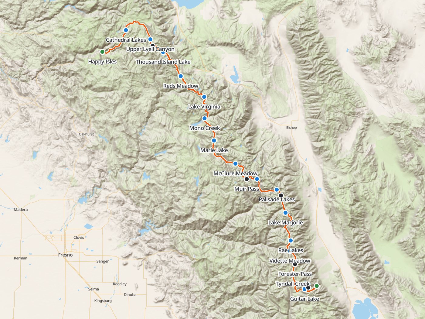
The southbound route with the fifteen camps of the plan below. Map data © OpenStreetMap contributors, elevation from Copernicus GLO-30.
Take the plan with you
The same sixteen-day plan opens in Backpackers Friend as a ready-made trip, with every camp and both trailheads already placed, and the app routes between them along the trail. On a computer, scan the code with your phone's camera. On a phone, tap the button instead. With Premium, download the map before you leave and the route works in airplane mode. The GPX file carries the same route and waypoints for any other mapping tool.
The GPX route comes from OpenStreetMap data under the Open Database License.
The fifteen-night plan, southbound
The John Muir Trail has no single agency mileage table, so the mileages here are measured along the trail line and scaled to the published 211 miles at the summit of Mount Whitney. Climbing and camp elevations come from a 30-meter elevation model, so treat every figure as a close estimate rather than a survey number.
| Day | Route | Miles | Climb | Descent | Camp |
|---|---|---|---|---|---|
| 1 | Happy Isles trailhead to Upper Cathedral Lake | 16.2 | 6,450 ft | 850 ft | 9,600 ft |
| 2 | Upper Cathedral Lake to Upper Lyell Canyon | 15.5 | 1,050 ft | 1,650 ft | 9,000 ft |
| 3 | Upper Lyell Canyon to Thousand Island Lake | 10.1 | 2,650 ft | 1,500 ft | 10,200 ft |
| 4 | Thousand Island Lake to Reds Meadow | 16.5 | 2,050 ft | 4,500 ft | 7,700 ft |
| 5 | Reds Meadow to Lake Virginia | 16.0 | 4,300 ft | 1,600 ft | 10,400 ft |
| 6 | Lake Virginia to Quail Meadows | 13.7 | 2,100 ft | 4,450 ft | 8,000 ft |
| 7 | Quail Meadows to Marie Lake | 12.0 | 3,600 ft | 1,050 ft | 10,600 ft |
| 8 | Marie Lake to McClure Meadow | 18.7 | 2,400 ft | 3,300 ft | 9,700 ft |
| 9 | McClure Meadow to Big Pete Meadow | 15.8 | 2,600 ft | 3,000 ft | 9,200 ft |
| 10 | Big Pete Meadow to Lower Palisade Lake | 12.6 | 2,750 ft | 1,400 ft | 10,600 ft |
| 11 | Lower Palisade Lake to Lake Marjorie | 11.8 | 2,750 ft | 2,250 ft | 11,100 ft |
| 12 | Lake Marjorie to Rae Lakes | 15.5 | 3,050 ft | 3,600 ft | 10,600 ft |
| 13 | Rae Lakes to Vidette Meadow | 7.3 | 1,500 ft | 2,550 ft | 9,600 ft |
| 14 | Vidette Meadow to Tyndall Creek | 12.5 | 3,550 ft | 2,050 ft | 11,100 ft |
| 15 | Tyndall Creek to Guitar Lake | 11.9 | 2,250 ft | 1,800 ft | 11,500 ft |
| 16 | Guitar Lake to Whitney Portal | 15.6 | 3,400 ft | 6,500 ft |
Elevation along the John Muir Trail. Blue dots mark the fifteen camps, and the larger dots mark the nine passes and the summit of Mount Whitney.
Day 1. Happy Isles to Cathedral Lakes, 16.5 miles
The longest climb of the trip comes first, about 6,400 feet up from the valley floor past Vernal and Nevada falls and through Little Yosemite Valley. Yosemite does not allow a Happy Isles permit holder bound for Donohue Pass to spend the first night in Little Yosemite Valley, so continue past Sunrise to the Cathedral Lakes below Cathedral Peak.
Day 2. Cathedral Lakes to upper Lyell Canyon, 15.2 miles
The trail drops over Cathedral Pass to Tuolumne Meadows at mile 22.7, where the post office holds resupply packages from roughly mid-June to mid-September. The rest of the day follows the gentle Lyell Fork of the Tuolumne up Lyell Canyon to camps at the head of the valley.
Day 3. Lyell Canyon over Donohue Pass to Thousand Island Lake, 10.1 miles
Donohue Pass, at 11,056 feet and mile 35.8, marks the southern boundary of Yosemite and the first high pass of the walk. The trail crosses Island Pass and drops to Thousand Island Lake below Banner Peak, a short day that helps with acclimatization.
Day 4. Thousand Island Lake to Reds Meadow, 16.5 miles
The trail passes Garnet Lake and Rosalie Lake and descends more than 4,000 feet through forest to Reds Meadow near Devils Postpile, the second resupply stop. Check road and shuttle status ahead of time, because the Reds Meadow Road is under reconstruction.
Day 5. Reds Meadow to Lake Virginia, 16.2 miles
A long climb of about 4,300 feet leads out of the Reds Meadow valley, past the Duck Pass junction and Purple Lake, to the broad alpine basin of Lake Virginia.
Day 6. Lake Virginia over Silver Pass to Mono Creek, 13.5 miles
The trail drops into Tully Hole, climbs to Silver Pass at mile 81, and descends past a chain of lakes to camps along Mono Creek near Quail Meadows.
Day 7. Mono Creek to Marie Lake, 12.0 miles
The day climbs about 3,600 feet up Bear Ridge and the Bear Creek drainage, past Rosemarie Meadow, to Marie Lake just below Selden Pass.
Day 8. Marie Lake to McClure Meadow, 18.7 miles
Selden Pass at mile 101 opens onto the Sallie Keyes Lakes and a long descent to the junction for Muir Trail Ranch, the third resupply point, near mile 107. The trail crosses Piute Creek into Kings Canyon National Park and climbs along the South Fork San Joaquin into Evolution Valley and McClure Meadow, the longest day of the plan.
Day 9. McClure Meadow over Muir Pass to Big Pete Meadow, 15.8 miles
The trail climbs past Evolution Lake and Wanda Lake to Muir Pass at 11,955 feet, where the stone Muir Hut stands on the pass. The park advises against sheltering in summit huts during lightning. The descent follows the Middle Fork Kings into LeConte Canyon and Big Pete Meadow.
Day 10. Big Pete Meadow to the Palisade Lakes, 12.6 miles
The trail descends LeConte Canyon to Palisade Creek, then climbs the Golden Staircase to the Palisade Lakes, the last good camps below Mather Pass.
Day 11. Palisade Lakes over Mather Pass to Lake Marjorie, 11.9 miles
Mather Pass, near 12,100 feet at mile 150.8, leads into Upper Basin and the headwaters of the South Fork Kings. The trail crosses the river and climbs to Lake Marjorie, a high camp just north of Pinchot Pass.
Day 12. Lake Marjorie over Pinchot Pass to the Rae Lakes, 15.4 miles
Pinchot Pass, above 12,000 feet, opens a long descent to the suspension bridge at Woods Creek, mile 168.6. The trail then climbs past Dollar Lake and Arrowhead Lake to the Rae Lakes. Kings Canyon allows one night per lake from Dollar Lake to Glen Pass, and bear canisters are required in the Rae Lakes area.
Day 13. Rae Lakes over Glen Pass to Vidette Meadow, 7.3 miles
Glen Pass rises 11,978 feet above the Rae Lakes. The descent passes the Charlotte Lake junction, where Charlotte Lake allows two nights and Bullfrog Lake is closed to camping, to Vidette Meadow on Bubbs Creek. The short day sets up the climb to the highest pass on the trail.
Day 14. Vidette Meadow over Forester Pass to Tyndall Creek, 12.5 miles
Forester Pass, above 13,000 feet at mile 189.5, is the highest pass on the John Muir Trail and the boundary between Kings Canyon and Sequoia. Cross early in the day, before afternoon storms build, and camp along Tyndall Creek on the far side.
Day 15. Tyndall Creek to Guitar Lake, 11.9 miles
The trail crosses the Bighorn Plateau, passes the Crabtree Meadow ranger station, and climbs to Guitar Lake, the last campsite with water before the summit. Sequoia allows two nights at most at Crabtree Meadow and Guitar Lake. Above Crabtree the trail enters the Whitney Zone, where all human waste must be packed out.
Day 16. Over Mount Whitney to Whitney Portal, 15.6 miles
Start before dawn. The trail switchbacks to the junction below Trail Crest, and the summit spur leads to the top of Mount Whitney at 14,505 feet, mile 211. No reliable water exists between Guitar Lake and Trail Camp. From the summit, the Mt. Whitney Trail descends 10.7 miles past Trail Camp and Outpost Camp to Whitney Portal.
Permits
- One permit covers the whole trail. Yosemite says a continuous John Muir Trail hike needs only one Yosemite wilderness permit, with no separate Whitney permit and no permits from the other parks and forests.
- Choose a Donohue-eligible trailhead. Happy Isles to Past Little Yosemite Valley and Lyell Canyon both qualify for the Donohue Pass exit, which allows 45 people a day, 15 from Happy Isles and 30 from Lyell Canyon.
- Enter the weekly lottery 24 weeks ahead. Yosemite awards 60 percent of each trailhead's quota by lottery, with applications open Sunday through Saturday and results by 5:00 PM the following Monday. The remaining 40 percent go on sale seven days before the entry date.
- Fees are $10 per application and $5 per person on a confirmed permit, and both are nonrefundable.
- Half Dome is not included. Yosemite requires a separate Half Dome permit whenever the cables are up, even for backpackers holding a wilderness permit.
Resupply
Three resupply points sit on or near the trail. The Tuolumne Meadows post office accepts General Delivery packages from roughly mid-June to mid-September, and Yosemite advises marking each box with the date you expect to arrive. Reds Meadow, near Devils Postpile, depends on the Reds Meadow Road, which is under reconstruction. Muir Trail Ranch sits on a short spur off the trail near mile 107 and runs a resupply service of the ranch's own. Confirm each stop's current season and rules before you mail food, since all three change from year to year.
Rules on the trail
- Carry a bear canister the whole way. Yosemite requires approved canisters throughout the park and prohibits hanging food anywhere, Kings Canyon requires canisters in the Rae Lakes area, and Inyo National Forest requires them in the Whitney Zone.
- Pack out human waste in the Whitney Zone. Inyo requires pack-out kits there year round and forbids storing used kits in a bear canister.
- Camping limits include one night per lake from Dollar Lake to Glen Pass, two nights at Charlotte Lake, two nights at Crabtree Meadow and Guitar Lake, and no camping near Bullfrog Lake.
- Campfire limits vary by park and elevation. Kings Canyon prohibits fires above 10,000 feet, and the Whitney Zone prohibits fires at any elevation.
Getting to and from the trail
Happy Isles sits at the east end of Yosemite Valley, and long-term parking for wilderness permit holders needs no extra reservation. No public transit links Whitney Portal and Yosemite. Eastern Sierra Transit runs between Lone Pine and Mammoth Lakes, and YARTS runs between Mammoth Lakes and Yosemite Valley over Highway 120 when Tioga Road is open, so plan the return before you start.
When to go
The high passes hold snow into early summer, and the trail is busiest from July through September, when the passes have usually melted out. Muir Pass and Forester Pass are often the last to clear. Afternoon thunderstorms build over the crest in summer, so plan to reach each pass in the morning, and check current conditions with the parks before you go.
Water
Lakes and creeks supply water at every camp in the plan. The one stretch without reliable water runs from Guitar Lake over the summit of Mount Whitney to Trail Camp, so leave Guitar Lake with a full load. Treat all of the water.
Questions people ask
How long is the John Muir Trail?
The John Muir Trail runs 211 miles from Happy Isles in Yosemite Valley to the summit of Mount Whitney. Reaching the road at Whitney Portal adds another 10.7 miles down the Mt. Whitney Trail.
How many days does the John Muir Trail take?
Most hikers take two to three weeks. This plan walks the trail southbound in sixteen days at about fourteen miles a day, with the longest day at 18.7 miles.
What permit do you need for the John Muir Trail?
A continuous southbound walk needs one Yosemite wilderness permit from a trailhead that qualifies for the Donohue Pass exit, such as Happy Isles to Past Little Yosemite Valley or Lyell Canyon. Yosemite awards most of those permits through a weekly lottery 24 weeks before the entry date.
Do you need a separate permit to exit at Whitney Portal?
No. Yosemite says a continuous John Muir Trail hike needs only the Yosemite wilderness permit, with no separate Whitney permit. The Whitney Zone rules on waste and bear canisters still apply.
Where can you resupply on the John Muir Trail?
The three common resupply points are the Tuolumne Meadows post office, Reds Meadow near Devils Postpile, and Muir Trail Ranch near mile 107. Confirm each one's season and rules before you mail food.
What is the highest pass on the John Muir Trail?
Forester Pass, above 13,000 feet on the boundary between Kings Canyon and Sequoia, is the highest pass on the trail. The summit of Mount Whitney, at 14,505 feet, is the highest point.
Sources
The trail length, the single-permit rule, the Donohue Pass exit quota, resupply notes, canister rules, and transit come from Yosemite's John Muir and Pacific Crest trails page, and the lottery schedule and fees from the park's wilderness permits page. Camping limits in Kings Canyon and Sequoia come from the parks' minimum impact restrictions. Whitney Zone rules come from Inyo National Forest's Mt. Whitney Trail page, and Reds Meadow access from the forest's Reds Meadow Road page. Rules change between seasons, so confirm each one with the agencies before you go.
Plan the trip, then walk the plan
Backpackers Friend opens this plan as a trip on your phone, snaps the route to the trail, and lays the days out on a topo map. Planning is free with no account. Premium adds offline maps so the whole route works in airplane mode, plus off-trail alerts if you drift from the line.
