
PCT Northern Terminus Itinerary, Day by Day
The Pacific Crest Trail ends in the North Cascades at a small clearing on the Canadian border, three feet south of a metal obelisk called Monument 78, the 78th boundary marker counted from the Pacific. The closest road reaches the crest at Harts Pass, about 30 miles south, so even hikers who are not walking the whole trail can reach the terminus. Since January 2025 the border crossing is closed to PCT hikers, so the walk is an out-and-back. The plan below covers the 60 miles from Harts Pass to the monument and back over five days.
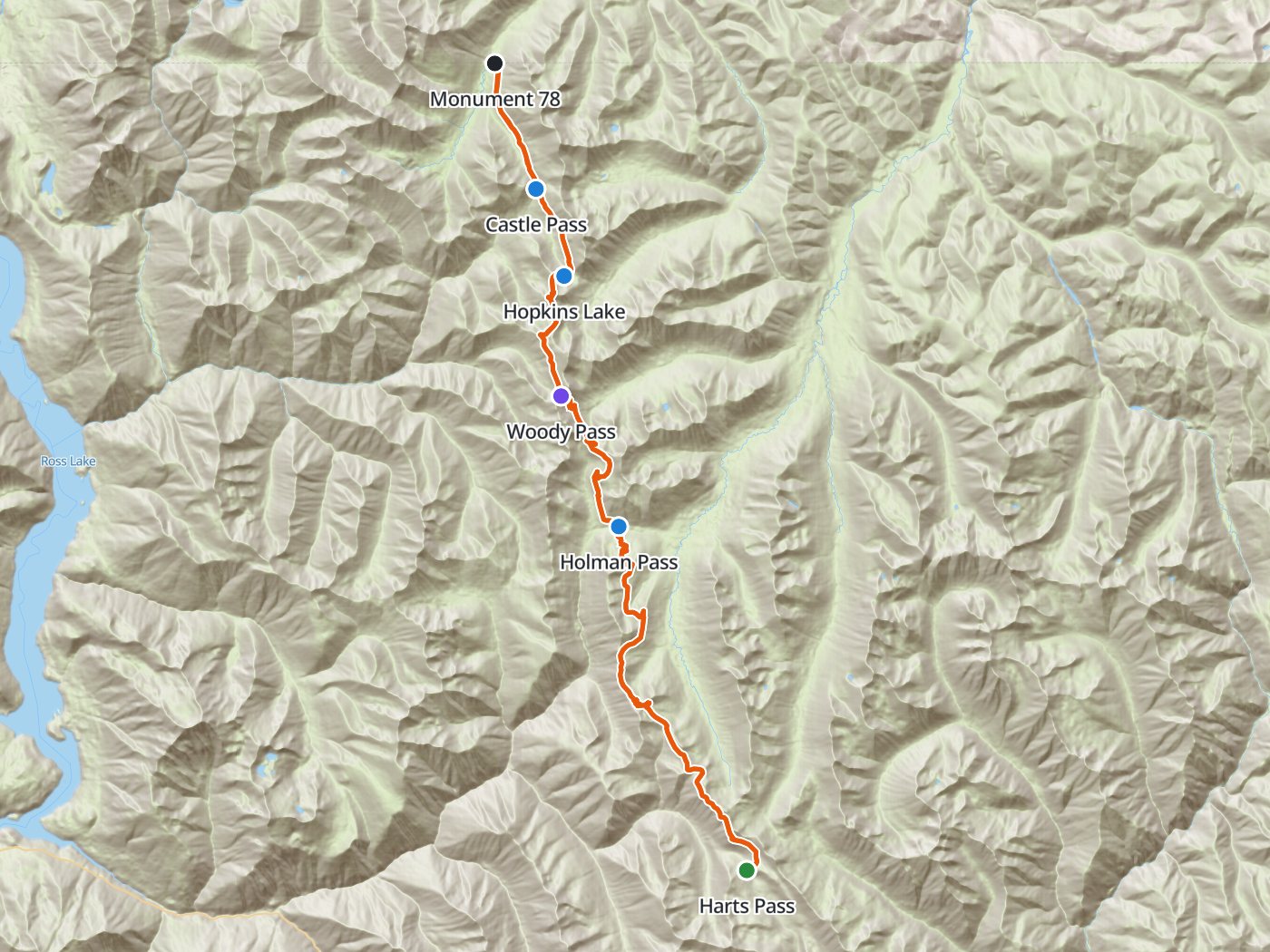
The route north from Harts Pass to the border, walked back the same way. Map data © OpenStreetMap contributors, elevation from Copernicus GLO-30.
Take the plan with you
The same four-night plan opens in Backpackers Friend as a ready-made trip, with the camps, the monument, and the trailhead already placed, and the app routes between them along the trail. On a computer, scan the code with your phone's camera. On a phone, tap the button instead. With Premium, download the map before you leave and the route works in airplane mode. The GPX file carries the same route and waypoints for any other mapping tool.
The GPX route comes from OpenStreetMap data under the Open Database License.
The four-night plan, out and back
Mileages are measured along the trail line, which puts Monument 78 about 30 miles from Harts Pass, matching the Pacific Crest Trail Association's figure. Climbing and camp elevations come from a 30-meter elevation model, so treat them as close estimates.
| Day | Route | Miles | Climb | Descent | Camp |
|---|---|---|---|---|---|
| 1 | Harts Pass trailhead to Holman Pass | 13.4 | 2,300 ft | 3,350 ft | 5,100 ft |
| 2 | Holman Pass to Castle Pass | 13.1 | 3,400 ft | 3,050 ft | 5,500 ft |
| 3 | Castle Pass to Monument 78 and back to Hopkins Lake | 9.8 | 2,550 ft | 1,800 ft | 6,300 ft |
| 4 | Hopkins Lake to Holman Pass | 10.5 | 2,000 ft | 3,100 ft | 5,100 ft |
| 5 | Holman Pass to Harts Pass | 13.4 | 3,400 ft | 2,350 ft |
Elevation out and back along the crest. Blue dots mark the four camps, and the larger dot marks Monument 78.
Day 1. Harts Pass to Holman Pass, 13.4 miles
The trail leaves Harts Pass near 6,200 feet and stays high along the crest of the Cascades for most of the day, with long views west into the North Cascades. Camps lie near Holman Pass at mile 13.4.
Day 2. Holman Pass to Castle Pass, 13.1 miles
The route climbs over Rock Pass and Woody Pass at mile 19.4 and traverses above Hopkins Lake to Castle Pass at mile 26.5, the last camp before the border.
Day 3. To Monument 78 and back to Hopkins Lake, 9.8 miles
The trail descends about 3.6 miles through forest to the clearing at the border, where the northern terminus monument stands beside Monument 78 at mile 30.1. Sign the register, then turn around, since crossing into Canada on the trail is prohibited. Walk back over Castle Pass to camp at Hopkins Lake.
Day 4. Hopkins Lake to Holman Pass, 10.5 miles
The route retraces the crest south past Woody Pass to camps near Holman Pass.
Day 5. Holman Pass to Harts Pass, 13.4 miles
The last day follows the crest back to the trailhead at Harts Pass.
The closed border
Canada's border agency ended the Pacific Crest Trail entry permit program in January 2025, so crossing the border on the trail is now prohibited. Hikers who reach the northern terminus are expected to turn around and walk back to Harts Pass or another trailhead. The Pacific Crest Trail Association also does not issue permits that start in E. C. Manning Provincial Park on the Canadian side.
Permits
- Fill out a wilderness permit at the trailhead. The Okanogan-Wenatchee National Forest requires a permit to enter the Pasayten Wilderness, and the self-issued permits are free.
- The PCT long-distance permit from the Pacific Crest Trail Association covers trips of 500 miles or more, so a section hike from Harts Pass uses the local permit instead.
Getting to the trailhead
From Winthrop, drive west on Highway 20 and up the Lost River Road, which turns to gravel and becomes the Harts Pass Road, Forest Service Road 5400, for the climb to the pass. The road is narrow, and the Forest Service closes the road to trailers from June 1 to December 31. The trailhead is usually reachable from July through September. Forest Service pages disagree on whether a Northwest Forest Pass is required at Harts Pass, so check with the Methow Valley Ranger District before you go.
When to go
The Harts Pass trailhead is usually reachable from July through September, which sets the season. Snow lingers on the north sides of the passes into July in many years, and early autumn brings colder nights and the first storms.
Water
Water along the crest comes from snowmelt streams and lakes and varies with the season and the snowpack. Ask the Methow Valley Ranger District about current sources before you go, carry enough between them, and treat all of the water.
Questions people ask
How far is the PCT northern terminus from Harts Pass?
Monument 78 sits about 30 miles north of Harts Pass, so the out-and-back walk runs about 60 miles.
Can you cross into Canada at the end of the PCT?
No. Canada ended the Pacific Crest Trail entry permit program in January 2025, and crossing the border on the trail is now prohibited. Hikers turn around at the terminus.
Do you need a permit to hike from Harts Pass to the border?
Yes. The Pasayten Wilderness requires a wilderness permit, which is free and self-issued at the trailhead.
Can you drive a trailer to Harts Pass?
No. The Forest Service closes the narrow Harts Pass Road to trailers from June 1 to December 31.
Sources
The terminus location, the closed border, and the permit policy for the Canadian end come from the Pacific Crest Trail Association's northern terminus page and the association's border announcement. The wilderness permit, road, trailer rule, and season come from the Okanogan-Wenatchee National Forest's Pacific Crest Trail page and Harts Pass trailhead page. Rules change between seasons, so confirm each one with the forest before you go.
Plan the trip, then walk the plan
Backpackers Friend opens this plan as a trip on your phone, snaps the route to the trail, and lays the days out on a topo map. Planning is free with no account. Premium adds offline maps so the whole route works in airplane mode, plus off-trail alerts if you drift from the line.
