
Rae Lakes Loop Itinerary, Day by Day
The Rae Lakes Loop leaves Road's End at the bottom of Kings Canyon, climbs Paradise Valley and Woods Creek to the chain of lakes beneath Fin Dome, crosses 11,978-foot Glen Pass, and drops back down Bubbs Creek to the car. The National Park Service measures the circuit at 41.4 miles. The plan below walks the loop clockwise over four nights, with every camp beside a creek or lake and the hardest climbing split across three days.
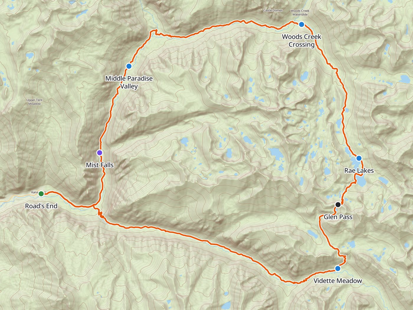
The clockwise loop with the four camps of the plan below. Map data © OpenStreetMap contributors, elevation from Copernicus GLO-30.
Take the plan with you
The same four-night plan opens in Backpackers Friend as a ready-made trip, with every camp, the pass, and the trailhead already placed, and the app routes between them along the trail. On a computer, scan the code with your phone's camera. On a phone, tap the button instead. With Premium, download the map before you leave and the loop works in airplane mode. The GPX file carries the same route and waypoints for any other mapping tool.
The GPX route comes from OpenStreetMap data under the Open Database License.
The four-night plan, clockwise
Mileages are the park's published figures. Climbing and camp elevations come from a 30-meter elevation model sampled along the trail, so treat them as close estimates rather than survey numbers.
| Day | Route | Miles | Climb | Descent | Camp |
|---|---|---|---|---|---|
| 1 | Road's End to Middle Paradise Valley | 6.8 | 1,900 ft | 300 ft | 6,700 ft |
| 2 | Middle Paradise Valley to Woods Creek Crossing | 8.9 | 2,100 ft | 150 ft | 8,600 ft |
| 3 | Woods Creek Crossing to the Rae Lakes | 7.0 | 2,000 ft | 50 ft | 10,600 ft |
| 4 | Rae Lakes over Glen Pass to Vidette Meadow | 5.5 | 1,450 ft | 2,500 ft | 9,600 ft |
| 5 | Vidette Meadow down Bubbs Creek to Road's End | 13.2 | 200 ft | 4,650 ft |
Elevation along the clockwise loop. Blue dots mark the four camps, and the larger dot marks Glen Pass at mile 24.6.
Day 1. Road's End to Middle Paradise Valley, 6.8 miles
The trail follows the north bank of the South Fork Kings River for 1.9 miles to the junction where the loop splits, then turns north up the Paradise Valley trail. Mist Falls comes at mile 3.9, and camping is not allowed there. Lower Paradise Valley at mile 5.7 is the first legal camp, and sites there are designated, so camp only in the marked spots. Middle Paradise at mile 6.8 adds one more mile and makes the second day shorter. Paradise Valley allows two nights at most.
Day 2. Middle Paradise Valley to Woods Creek Crossing, 8.9 miles
The valley stays gentle past Upper Paradise at mile 10, where the trail crosses the South Fork and turns east up Woods Creek. The bridge at that crossing washed out in the winter of 2016 to 2017, and the park says a replacement will not begin before 2027. Depending on flow, the ford can be extremely hazardous, and the park advises hikers to be prepared to turn back. From the river the trail climbs steadily up the Woods Creek canyon to the suspension bridge at Woods Creek Crossing, mile 15.7, where the loop joins the John Muir Trail.
Day 3. Woods Creek Crossing to the Rae Lakes, 7.0 miles
The loop now follows the John Muir Trail south, climbing about 2,000 feet past Dollar Lake at mile 19.7 and Arrowhead Lake into the Rae Lakes basin at mile 22.7. Camping is limited to one night per lake from Dollar Lake to Glen Pass, and fires are prohibited above 10,000 feet, which covers every camp in the basin. A short day here leaves the afternoon for the lakes and an early start on the pass.
Day 4. Over Glen Pass to Vidette Meadow, 5.5 miles
Glen Pass sits 1.9 miles above the Rae Lakes at 11,978 feet, the high point of the loop. The park warns that the pass may be impassable to hikers until mid to late July. The south side drops past the Charlotte Lake junction at mile 26.7, where Charlotte Lake allows two nights and Bullfrog Lake, east of the trail, is closed to camping. Vidette Meadow at mile 28.2 is where the loop leaves the John Muir Trail for Bubbs Creek.
Day 5. Vidette Meadow to Road's End, 13.2 miles
The longest day is nearly all downhill, losing about 4,650 feet along Bubbs Creek. The trail passes Junction Meadow at mile 31.1 and Charlotte Creek at mile 33.9. Sphinx Junction at mile 37.5 is the last campsite on the loop. The Bubbs Creek trail rejoins the outbound route at the junction 1.9 miles above Road's End.
Three nights or five
Three nights asks for one long climbing day. The second day runs 12.7 miles from Upper Paradise Valley to the Rae Lakes and gains about 3,800 feet, most of the loop's climbing.
| Day | Route | Miles | Climb | Descent |
|---|---|---|---|---|
| 1 | Road's End to Upper Paradise Valley | 10.0 | 2,200 ft | 300 ft |
| 2 | Upper Paradise Valley to the Rae Lakes | 12.7 | 3,800 ft | 150 ft |
| 3 | Rae Lakes over Glen Pass to Junction Meadow | 8.4 | 1,450 ft | 3,750 ft |
| 4 | Junction Meadow to Road's End | 10.3 | 200 ft | 3,400 ft |
Five nights keeps every day under 11 miles and uses both of the nights Paradise Valley allows.
| Day | Route | Miles | Climb | Descent |
|---|---|---|---|---|
| 1 | Road's End to Lower Paradise Valley | 5.7 | 1,750 ft | 100 ft |
| 2 | Lower to Upper Paradise Valley | 4.3 | 500 ft | 200 ft |
| 3 | Upper Paradise Valley to Woods Creek Crossing | 5.7 | 1,750 ft | 150 ft |
| 4 | Woods Creek Crossing to the Rae Lakes | 7.0 | 2,000 ft | 50 ft |
| 5 | Rae Lakes over Glen Pass to Junction Meadow | 8.4 | 1,450 ft | 3,750 ft |
| 6 | Junction Meadow to Road's End | 10.3 | 200 ft | 3,400 ft |
Clockwise or counterclockwise
The entry trailhead on your permit sets the direction, and both trailheads start at Road's End. Woods Creek sends you clockwise up Paradise Valley, and Bubbs Creek sends you counterclockwise. Clockwise reaches Glen Pass after 24.6 miles of gradual climbing, while counterclockwise gains the same pass in 16.8 miles, nearly all of that distance uphill along Bubbs Creek. Clockwise also meets the unbridged South Fork crossing on the second day, when turning back costs a day. Counterclockwise meets the crossing near the end of the loop, and the park warns that hikers starting from Bubbs Creek may need to backtrack to reach Cedar Grove safely.
Permits
- Every overnight trip needs a wilderness permit. During the quota season, which ran May 22 to September 26 in 2026, entries are limited per trailhead per day.
- Reservations open six months before the entry date on Recreation.gov, released daily at 7:00 AM Pacific, and close one week before entry. A start on July 24, 2027 opens for booking around January 24, 2027.
- A reservation costs $15 per trip plus $5 per person. The per-person fee is refundable for cancellations made at least a week out.
- Pick up the permit at the Road's End Permit Station between 1:00 PM the day before entry and 10:00 AM on the entry day. The park cancels unclaimed reservations at 10:00 AM unless you call ahead.
- Walk-up permits go on sale at 1:00 PM the day before entry, at the same station, during ranger hours.
- Outside the quota season, a self-issue kiosk at Road's End is available around the clock.
Rules on the loop
- Bear canisters are required. The canister area covers the whole loop from the Friday before Memorial Day through October 31. The metal food boxes along the trail are reserved for Pacific Crest Trail and John Muir Trail thru-hikers.
- Paradise Valley allows two nights, and Lower Paradise allows camping only in designated sites.
- The Rae Lakes allow one night per lake, and the same one-night limit applies to every lake from Dollar Lake to Glen Pass.
- Charlotte Lake and the Kearsarge Lakes allow two nights. Bullfrog Lake is closed to all camping.
- Campfires are prohibited above 10,000 feet.
- Pets are not allowed on any trail in the park.
When to go
Highway 180 into Cedar Grove and Road's End is seasonal. The road usually reopens in late April and closes in mid-November, and the park expected the 2026 closure on November 13. Inside that window, the trail sets a tighter one. Stream crossings run high in May and early June, Glen Pass can hold impassable snow into late July, and the South Fork ford above Paradise Valley stays dangerous until the snowmelt drops. A start between mid-July and mid-September is the most reliable window. Check the park's current conditions before you commit to a date, since a big snow year pushes every one of those dates later.
Water
Water is not the limiting factor on this loop. The route follows the South Fork Kings River, Woods Creek, the Rae Lakes chain, and Bubbs Creek, and every camp in the plans above sits beside a lake or a creek. Treat all of the water.
Questions people ask
How long is the Rae Lakes Loop?
The National Park Service measures the loop at 41.4 miles from Road's End, with the high point at 11,978-foot Glen Pass. Measured from a 30-meter elevation model, the loop climbs about 7,600 feet in total.
How many days does the Rae Lakes Loop take?
Most parties take four nights and five days. Strong hikers finish in three nights, which means a 12.7-mile day with about 3,800 feet of climbing from Upper Paradise Valley to the Rae Lakes. Five nights keeps every day under 11 miles.
Do you need a permit for the Rae Lakes Loop?
Every overnight trip needs a wilderness permit from Sequoia and Kings Canyon National Parks. During the quota season, which ran May 22 to September 26 in 2026, reservations open on Recreation.gov six months before the entry date at 7:00 AM Pacific, and walk-up permits go on sale at 1:00 PM the day before entry at the Road's End Permit Station. A reservation costs $15 per trip plus $5 per person.
When is the Rae Lakes Loop free of snow?
The park warns that Glen Pass may be impassable to hikers until mid to late July, and stream crossings run high in May and early June. Since the South Fork Kings River bridge above Paradise Valley washed out in the winter of 2016 to 2017, the park says a full loop may not be possible until sometime in July.
Should you hike the Rae Lakes Loop clockwise or counterclockwise?
Clockwise from the Woods Creek trailhead spreads the climb to Glen Pass over 24.6 miles and reaches the unbridged South Fork crossing on the second day, early enough to turn back cheaply. Counterclockwise from the Bubbs Creek trailhead gains the pass in 16.8 miles and meets the crossing near the end, where the park warns hikers may need to backtrack.
Can you have a campfire on the Rae Lakes Loop?
Campfires are prohibited above 10,000 feet, which rules out the Rae Lakes, Glen Pass, and Dollar Lake. Below that line, fires follow the park's current fire restrictions, so check them before the trip.
Sources
Mileages, camping limits, the bridge closure, and seasonal warnings come from the National Park Service's Rae Lakes Loop page. Permit dates, fees, and pickup hours come from the wilderness permits page, the canister season from the bear canister area descriptions, and road dates from the road information page. Rules change between seasons, so confirm each one with the park before you go.
Plan the loop, then walk the loop
Backpackers Friend opens this plan as a trip on your phone, snaps the route to the trail, and lays the loop out on a topo map. Planning is free with no account. Premium adds offline maps so the whole loop works in airplane mode, plus off-trail alerts if you drift from the line.
