
Enchantments Through-Hike Itinerary, Day by Day
The Enchantments are a high basin of granite, larches, and small lakes in the Alpine Lakes Wilderness above Leavenworth. The classic through-hike starts at the Stuart Lake trailhead, climbs past Colchuck Lake and straight up Aasgard Pass into the Core Enchantment Zone, and descends past the Snow Lakes to the Snow Lakes trailhead, about 18 miles in all. The plan below spends one night in the Core on a lottery permit. Walking the same route in a single day needs only a free day-use permit, though the distance and the climb make that day very long.
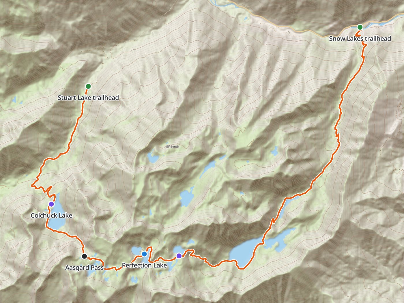
The through-hike from west to east, with the camp in the Core Enchantments. Map data © OpenStreetMap contributors, elevation from Copernicus GLO-30.
Take the plan with you
The same plan opens in Backpackers Friend as a ready-made trip, with the camp and both trailheads already placed, and the app routes between them along the trail. On a computer, scan the code with your phone's camera. On a phone, tap the button instead. With Premium, download the map before you leave and the route works in airplane mode. The GPX file carries the same route and waypoints for any other mapping tool.
The GPX route comes from OpenStreetMap data under the Open Database License.
The one-night plan, west to east
Mileages are measured along the trail line. Climbing and camp elevations come from a 30-meter elevation model sampled along the trail, so treat them as close estimates rather than survey numbers.
| Day | Route | Miles | Climb | Descent | Camp |
|---|---|---|---|---|---|
| 1 | Stuart Lake trailhead to Perfection Lake | 7.1 | 4,400 ft | 700 ft | 7,200 ft |
| 2 | Perfection Lake to Snow Lakes trailhead | 10.9 | 400 ft | 6,200 ft |
Elevation along the through-hike. The blue dot marks the camp at Perfection Lake, and the larger dot marks Aasgard Pass.
Day 1. Stuart Lake trailhead over Aasgard Pass to Perfection Lake, 7.1 miles
The trail climbs through forest to the turquoise water of Colchuck Lake at mile 4.0, then rounds the lake to the foot of Aasgard Pass. The pass climbs straight up a steep gully of rock and talus to the rim near 7,800 feet at mile 5.5. The Forest Service warns that the pass is often snow-covered, usually melts out by late June, and is especially hazardous on snow because of hidden rocks, creeks, and waterfalls. The top opens onto the Core Enchantments, and the route descends past the upper lakes to camps around Perfection Lake. Use the toilets where they stand, and keep urine on bare rock and away from camps, since the salt draws mountain goats.
Day 2. Perfection Lake to the Snow Lakes trailhead, 10.9 miles
The route continues down through the Core past Lake Viviane and descends a long granite stairway to the Snow Lakes, then drops past Nada Lake to the Snow Lakes trailhead near 1,300 feet. The day loses more than 6,000 feet, so knees take the beating.
Two nights in the Core
Two nights in the Core turn the middle day into a short move from Perfection Lake to Lake Viviane, with time to wander the upper basin.
| Day | Route | Miles | Climb | Descent |
|---|---|---|---|---|
| 1 | Stuart Lake trailhead to Perfection Lake | 7.1 | 4,400 ft | 700 ft |
| 2 | Perfection Lake to Lake Viviane | 1.3 | 50 ft | 300 ft |
| 3 | Lake Viviane to Snow Lakes trailhead | 9.6 | 300 ft | 5,900 ft |
Permits
- Permits are required for day and overnight use. Day-use permits are free and self-issued at the three trailheads.
- Overnight permits are required from May 15 to October 31 and come only from Recreation.gov. Each permit names one of five zones, and the Core Enchantment Zone is the most competitive.
- The advanced lottery ran from February 15 to March 1 in 2026, with results around March 15. The Forest Service says the lottery issues roughly 75 percent of permits and that typically fewer than 10 percent of applicants win.
- The daily lottery issues a small number of permits the day before a trip to applicants within a mile of the Wenatchee River Ranger District office in Leavenworth.
- Fees are a $6 application fee and $5 per person per day for overnight permits.
Rules on the trail
- Groups are limited to eight people, stock included, at all times.
- Dogs and other pets are prohibited, except service animals. Drones are not allowed.
- Hang food, toiletries, and other attractive items, and keep camp waste away from bears, mice, and goats.
- Use the toilets where provided. Elsewhere, dig a cat hole 6 to 8 inches deep at least 200 feet from water and camps, and pack out toilet paper.
- Wash 150 to 200 feet from lakes and streams, with no soap in the water.
Getting to the trailheads
Both trailheads sit off Icicle Road outside Leavenworth. The Stuart Lake trailhead lies at the end of Forest Service Road 7601, where cars must park on the right side of the road going up, and overnight parking is reserved for permit holders. A vehicle needs a Northwest Forest Pass, an America the Beautiful pass, or the overnight parking pass that comes with the permit. The Forest Service encourages a shuttle between trailheads, since parking is limited.
When to go
Overnight permits cover May 15 to October 31. Snow usually clears from Aasgard Pass by late June, though patches can last all year. Early October brings the larches to gold, which is also when the daily lottery is most crowded.
Water
Lakes supply water throughout the Core and along the descent past the Snow Lakes. The climb up Aasgard Pass has little reliable water, so fill up at Colchuck Lake. Treat all of the water.
Questions people ask
How long is the Enchantments through-hike?
Measured along the trail line, the route from the Stuart Lake trailhead over Aasgard Pass to the Snow Lakes trailhead runs about 18 miles, with roughly 4,750 feet of climbing and 6,900 feet of descent.
How do you get an Enchantments permit?
Most overnight permits come from the advanced lottery on Recreation.gov, which ran from February 15 to March 1 in 2026. A small number go out in a daily lottery the day before a trip, for applicants in Leavenworth.
Can you hike the Enchantments in one day?
Yes, with a free self-issued day-use permit from the trailhead. The through-hike runs about 18 miles with a steep climb over Aasgard Pass, so start very early.
Which direction should you hike the Enchantments?
Most through-hikers start at the Stuart Lake trailhead and climb Aasgard Pass, which starts higher and avoids descending the steep, loose pass. The route then descends past the Snow Lakes.
Are dogs allowed in the Enchantments?
No. Dogs and all other pets are prohibited in the Enchantment Permit Area, except service animals.
Sources
Permits, zones, group size, prohibitions, food storage, sanitation, parking, and the Aasgard Pass warning come from the Okanogan-Wenatchee National Forest's Enchantments page. The lottery dates, odds, and fees come from the forest's overnight permits page and the Recreation.gov advanced lottery listing. Rules change between seasons, so confirm each one with the forest before you go.
Plan the trip, then walk the plan
Backpackers Friend opens this plan as a trip on your phone, snaps the route to the trail, and lays the days out on a topo map. Planning is free with no account. Premium adds offline maps so the whole route works in airplane mode, plus off-trail alerts if you drift from the line.
