
Wonderland Trail Itinerary, Day by Day
The Wonderland Trail circles Mount Rainier in about 93 miles, climbing out of one glacier-fed river valley after another into subalpine parks full of meadow and back down again. The park puts the total climb at roughly 27,000 feet, with the same amount of descent, and calls the walk strenuous. Every night is spent in a designated wilderness camp on a permit. The plan below walks the loop clockwise from Longmire in eleven days, using the park's own camp-to-camp mileages.
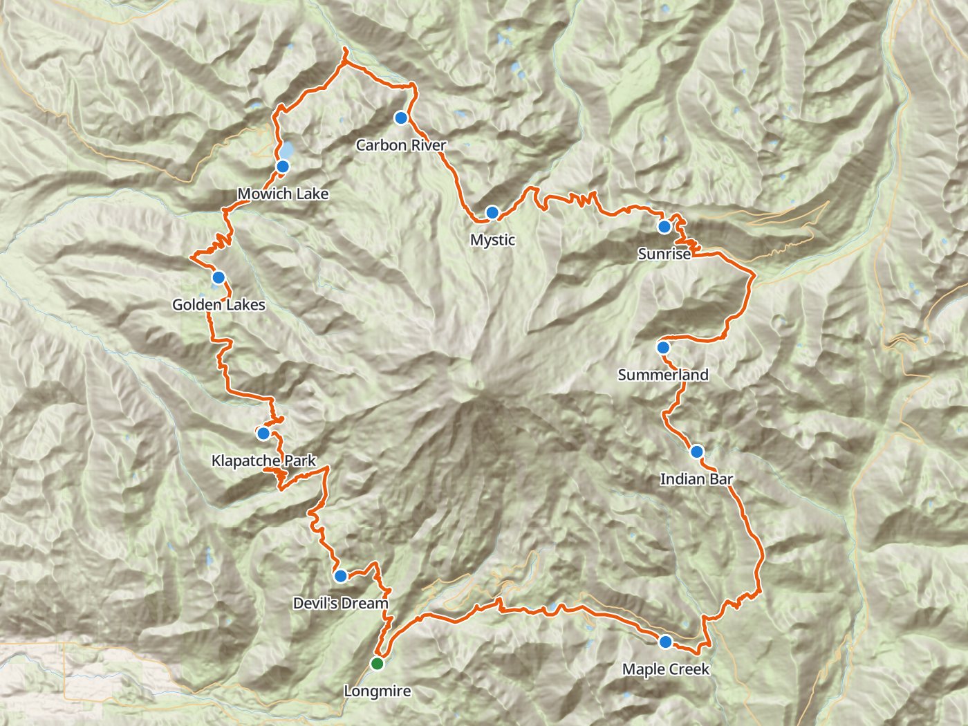
The clockwise loop with the ten camps of the plan below. Map data © OpenStreetMap contributors, elevation from Copernicus GLO-30.
Take the plan with you
The same ten-night plan opens in Backpackers Friend as a ready-made trip, with every camp and the trailhead already placed, and the app routes between them along the trail. On a computer, scan the code with your phone's camera. On a phone, tap the button instead. With Premium, download the map before you leave and the route works in airplane mode. The GPX file carries the same route and waypoints for any other mapping tool.
The GPX route comes from OpenStreetMap data under the Open Database License.
The ten-night plan, clockwise
Mileages are the park's published camp-to-camp distances, which add up to 94.1 miles around the loop. Climbing and camp elevations come from a 30-meter elevation model sampled along the trail, so treat them as close estimates rather than survey numbers.
| Day | Route | Miles | Climb | Descent | Camp |
|---|---|---|---|---|---|
| 1 | Longmire to Devil's Dream | 5.8 | 2,550 ft | 350 ft | 5,000 ft |
| 2 | Devil's Dream to Klapatche Park | 10.6 | 3,650 ft | 2,950 ft | 5,600 ft |
| 3 | Klapatche Park to Golden Lakes | 7.7 | 1,950 ft | 2,650 ft | 4,900 ft |
| 4 | Golden Lakes to Mowich Lake | 10.2 | 2,600 ft | 2,550 ft | 4,900 ft |
| 5 | Mowich Lake to Carbon River | 9.6 | 1,550 ft | 3,200 ft | 3,200 ft |
| 6 | Carbon River to Mystic | 5.0 | 2,850 ft | 500 ft | 5,600 ft |
| 7 | Mystic to Sunrise | 8.7 | 2,600 ft | 1,950 ft | 6,200 ft |
| 8 | Sunrise to Summerland | 10.5 | 2,250 ft | 2,550 ft | 5,900 ft |
| 9 | Summerland to Indian Bar | 4.7 | 1,000 ft | 1,800 ft | 5,100 ft |
| 10 | Indian Bar to Maple Creek | 10.4 | 1,450 ft | 3,700 ft | 2,900 ft |
| 11 | Maple Creek to Longmire (finish) | 10.9 | 2,350 ft | 2,450 ft |
Elevation around the Wonderland Trail. Blue dots mark the ten camps.
Day 1. Longmire to Devil's Dream, 5.8 miles
The loop leaves Longmire, where no camping is allowed, and climbs past Pyramid Creek to Devil's Dream, gaining about 2,550 feet on a short first day.
Day 2. Devil's Dream to Klapatche Park, 10.6 miles
The trail crosses Indian Henry's country, drops to the South Puyallup River at mile 12.3, and climbs to Klapatche Park at mile 16.4, a day of about 3,650 feet up and 2,950 down. Klapatche Park has no group site.
Day 3. Klapatche Park to Golden Lakes, 7.7 miles
The route descends to the North Puyallup River at mile 19.0 and climbs along Sunset Park to Golden Lakes at mile 24.1.
Day 4. Golden Lakes to Mowich Lake, 10.2 miles
The trail drops to the South Mowich River at mile 29.9 and climbs to Mowich Lake at mile 34.3, a non-wilderness campground reached by road.
Day 5. Mowich Lake to Carbon River, 9.6 miles
The Wonderland Trail crosses Ipsut Pass and descends to Ipsut Creek Campground at mile 39.9, then climbs the Carbon River valley to the Carbon River camp at mile 43.9. The Spray Park alternate leaves Mowich Lake for the high meadows of Spray Park and rejoins the main trail at Carbon River after 8.5 miles, with camps at Eagle's Roost and Cataract Valley along the way.
Day 6. Carbon River to Mystic, 5.0 miles
A short day with a steep climb of about 2,850 feet passes Dick Creek at mile 45.2 and climbs beside the Carbon Glacier to Mystic at mile 48.9.
Day 7. Mystic to Sunrise, 8.7 miles
The trail continues past Granite Creek at mile 53.0 to the Sunrise camp at mile 57.6, near the highest road in the park.
Day 8. Sunrise to Summerland, 10.5 miles
The route descends to White River Campground at mile 61.1 and climbs Fryingpan Creek to Summerland at mile 68.1, one of the most popular camps on the loop.
Day 9. Summerland over Panhandle Gap to Indian Bar, 4.7 miles
Panhandle Gap, near 6,750 feet, is the highest point on the trail and often holds snow into summer. The descent leads to Indian Bar at mile 72.8, a camp perched above the Ohanapecosh River.
Day 10. Indian Bar to Maple Creek, 10.4 miles
The longest descent of the trip, about 3,700 feet, passes Nickel Creek at mile 79.6 on the way down to Maple Creek at mile 83.2 in the Stevens Canyon forest.
Day 11. Maple Creek to Longmire, 10.9 miles
The last day climbs past Paradise River at mile 90.5 and descends to Longmire at mile 94.1 to close the loop.
Eight nights for a faster loop
Eight nights skip the short days, with camps at South Puyallup River, Golden Lakes, Mowich Lake, Carbon River, Granite Creek, White River, Indian Bar, and Maple Creek.
| Day | Route | Miles | Climb | Descent |
|---|---|---|---|---|
| 1 | Longmire to South Puyallup River | 12.3 | 4,350 ft | 2,750 ft |
| 2 | South Puyallup River to Golden Lakes | 11.8 | 3,800 ft | 3,250 ft |
| 3 | Golden Lakes to Mowich Lake | 10.2 | 2,600 ft | 2,550 ft |
| 4 | Mowich Lake to Carbon River | 9.6 | 1,550 ft | 3,200 ft |
| 5 | Carbon River to Granite Creek | 9.1 | 4,150 ft | 1,550 ft |
| 6 | Granite Creek to White River | 8.1 | 1,300 ft | 2,900 ft |
| 7 | White River to Indian Bar | 11.7 | 3,200 ft | 2,350 ft |
| 8 | Indian Bar to Maple Creek | 10.4 | 1,450 ft | 3,700 ft |
| 9 | Maple Creek to Longmire (finish) | 10.9 | 2,350 ft | 2,450 ft |
Permits
- Every overnight trip needs a wilderness permit naming the camp for each night.
- The early access lottery opens in February. Winners get a personal booking window in March or April and may make one reservation during that window.
- General reservations open April 25 on Recreation.gov for trips from June 1 to October 10. About two-thirds of summer permits are reservable, at least two days before the start.
- The other third is first come, first served at the Longmire, Paradise, and White River Wilderness Information Centers, no more than a day before the trip.
- Fees are $6 per reservation plus $12 per person per night, and park entrance fees still apply.
- Activate the permit in person with photo ID by noon on the start day, or the park cancels the reservation.
Rules on the trail
- Camp only in designated camps. Hikers doing the complete Wonderland Trail may not use cross-country zones.
- Summer parties are limited to five people. Groups of six to twelve need one of the group sites at 25 designated camps.
- Hang food on the storage poles at each camp, and carry a canister for subalpine camps without tall trees.
- Fires are prohibited in the backcountry. Stoves that burn white gas, canister fuel, or alcohol are allowed, but twig stoves are not.
- Pets and bicycles are not allowed on park trails, and firearms are prohibited throughout the park.
- Stay no more than four nights in a row at any one camp.
Food caches
The park accepts caches of food and fuel at several points around the loop during summer, which lets you carry only a few days of food at a time. The park's caching page lists the locations and the deadlines for dropping boxes.
When to go
The park describes the trail as mostly free of snow from mid-July to October, and advises against starting before mid to late July in an average snow year. Earlier trips call for winter skills, including fording dangerous glacier-fed rivers. Panhandle Gap holds snow longest.
Water
Rivers, creeks, and lakes supply water at every camp, and the park requires all water to be boiled or treated before drinking. Glacial rivers run silty, so fill from clear side streams where you can.
Questions people ask
How long is the Wonderland Trail?
The park describes the Wonderland Trail as about 93 miles with roughly 27,000 feet of climbing and the same amount of descent. The park's camp-to-camp mileages add up to 94.1 miles around the loop.
How many days does the Wonderland Trail take?
Most hikers take nine to twelve days. This plan walks the loop clockwise from Longmire in eleven days, and an eight-night variation finishes in nine.
How do you get a Wonderland Trail permit?
Enter Mount Rainier's early access lottery, which opens in February, or book on the general sale that opens April 25 on Recreation.gov. About a third of summer permits are held for walk-ups at the park's Wilderness Information Centers.
Can you have a campfire on the Wonderland Trail?
No. Mount Rainier prohibits fires in the backcountry. Gas, canister, and alcohol stoves are allowed.
When is the Wonderland Trail free of snow?
The park says the trail is usually mostly free of snow from mid-July to October, and advises waiting until mid to late July in an average snow year.
Sources
The distance, climbing, camp-to-camp mileages, the Spray Park alternate, and season come from Mount Rainier's Wonderland Trail page. The lottery, reservation dates, fees, and pickup rules come from the park's wilderness permits page, and camping, party size, food storage, and fire rules from the park's wilderness guidelines and regulations. Rules change between seasons, so confirm each one with the park before you go.
Plan the trip, then walk the plan
Backpackers Friend opens this plan as a trip on your phone, snaps the route to the trail, and lays the days out on a topo map. Planning is free with no account. Premium adds offline maps so the whole route works in airplane mode, plus off-trail alerts if you drift from the line.
