
Yosemite High Sierra Camps Loop Itinerary, Day by Day
Yosemite's five backcountry High Sierra Camps sit a day's walk apart in the high country south and west of Tuolumne Meadows. Linked together, the camps form a loop of about 47 miles that climbs to Vogelsang near 10,100 feet, drops to Merced Lake in a forested canyon, and returns past Sunrise, May Lake, and Glen Aulin on the Tuolumne River. The camps themselves are tent-cabin lodges, and backpackers stay in the designated campgrounds beside each one, with food lockers and short days between them. The plan below walks the loop clockwise over five nights.
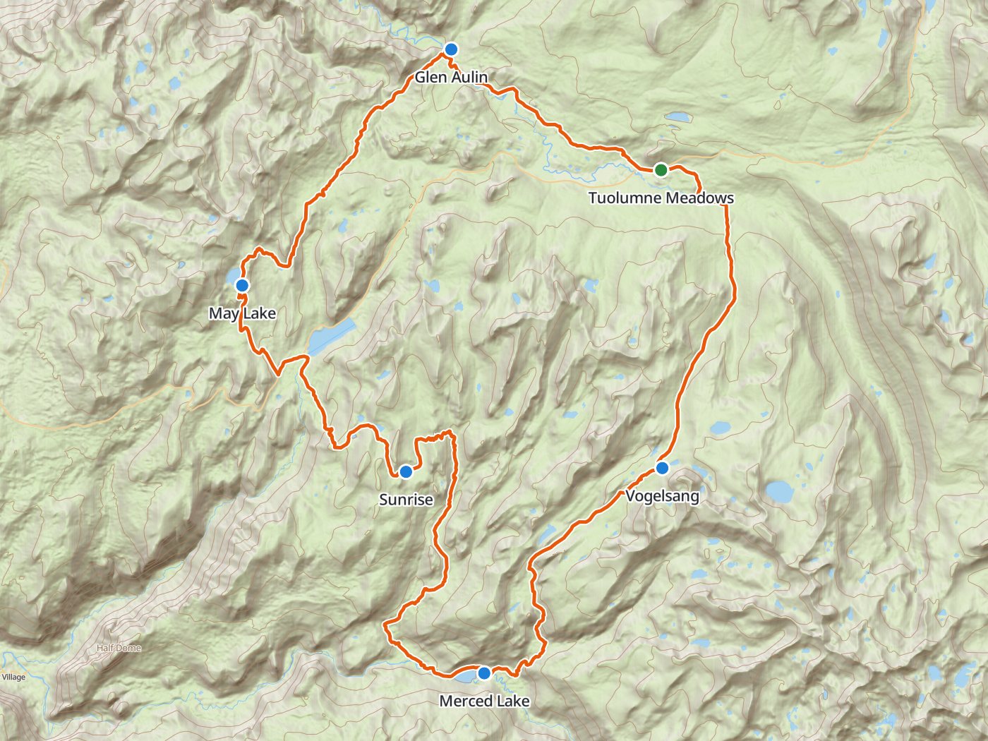
The clockwise loop with the five camps of the plan below. Map data © OpenStreetMap contributors, elevation from Copernicus GLO-30.
Take the plan with you
The same five-night plan opens in Backpackers Friend as a ready-made trip, with every camp and the trailhead already placed, and the app routes between them along the trail. On a computer, scan the code with your phone's camera. On a phone, tap the button instead. With Premium, download the map before you leave and the route works in airplane mode. The GPX file carries the same route and waypoints for any other mapping tool.
The GPX route comes from OpenStreetMap data under the Open Database License.
The five-night plan, clockwise
Mileages are measured along the trail line. Climbing and camp elevations come from a 30-meter elevation model sampled along the trail, so treat them as close estimates rather than survey numbers.
| Day | Route | Miles | Climb | Descent | Camp |
|---|---|---|---|---|---|
| 1 | Tuolumne Meadows trailhead to Vogelsang High Sierra Camp | 7.6 | 1,550 ft | 100 ft | 10,100 ft |
| 2 | Vogelsang High Sierra Camp to Merced Lake High Sierra Camp | 7.6 | 150 ft | 3,050 ft | 7,300 ft |
| 3 | Merced Lake High Sierra Camp to Sunrise High Sierra Camp | 9.9 | 2,650 ft | 550 ft | 9,400 ft |
| 4 | Sunrise High Sierra Camp to May Lake High Sierra Camp | 8.1 | 1,700 ft | 1,700 ft | 9,300 ft |
| 5 | May Lake High Sierra Camp to Glen Aulin High Sierra Camp | 8.0 | 550 ft | 1,950 ft | 7,900 ft |
| 6 | Glen Aulin High Sierra Camp to Tuolumne Meadows (finish) | 6.3 | 1,050 ft | 250 ft |
Elevation around the loop. Blue dots mark the five High Sierra Camps.
Day 1. Tuolumne Meadows to Vogelsang, 7.6 miles
The loop leaves Tuolumne Meadows on the John Muir Trail and turns south up Rafferty Creek, climbing about 1,550 feet to Vogelsang, the highest of the five camps. Vogelsang sits above Yosemite's 9,600-foot fire line, so no fires are allowed there.
Day 2. Vogelsang to Merced Lake, 7.6 miles
The trail descends more than 3,000 feet from the timberline basins around Vogelsang to Merced Lake, the lowest camp on the loop, in a forested canyon on the upper Merced River.
Day 3. Merced Lake to Sunrise, 9.9 miles
The longest climb of the trip gains about 2,650 feet out of the Merced canyon to the Sunrise camp, which sits at the edge of a long meadow with views of the Cathedral Range.
Day 4. Sunrise to May Lake, 8.1 miles
The trail drops past the Sunrise Lakes and crosses Tioga Road near Tenaya Lake, then climbs to May Lake beneath Mount Hoffmann.
Day 5. May Lake to Glen Aulin, 8.0 miles
The route descends about 1,950 feet north to Glen Aulin, where the camp sits beside the Tuolumne River at the foot of White Cascade.
Day 6. Glen Aulin to Tuolumne Meadows, 6.3 miles
The last day follows the Tuolumne River upstream through open granite and meadow back to Tuolumne Meadows, a gentle finish with about 1,050 feet of climbing.
Permits
- Reserve a Yosemite wilderness permit for the Rafferty Creek to Vogelsang trailhead. The park awards 60 percent of each trailhead's quota through a weekly lottery 24 weeks before the entry date and releases the other 40 percent seven days ahead.
- Fees are $10 per application and $5 per person on a confirmed permit.
- A wilderness permit does not reserve a High Sierra Camp. The tent cabins and meals are a separate concession. This plan uses the free backpacker campgrounds beside each camp.
Rules on the trail
- Camp in the designated campgrounds. Within a mile of each High Sierra Camp, Yosemite restricts camping to the designated backpacker campground.
- Camp at least four trail miles from Tuolumne Meadows and at least a mile from any road, which every camp on this loop satisfies.
- Carry a bear canister. Yosemite requires canisters throughout the wilderness and prohibits hanging food. Food lockers stand at the High Sierra Camp campgrounds.
- Fires are prohibited above 9,600 feet, which covers Vogelsang, and are allowed only in the communal rings at the other camp campgrounds.
- Groups are limited to 15 people. Pets are prohibited in the wilderness.
When to go
Tuolumne Meadows is reached by Tioga Road, which closes for winter and opens again once the snow is cleared, so check the opening date before you build a plan around early summer. Snow lingers longest around Vogelsang, the highest camp. Afternoon thunderstorms are common over the high country in summer.
Water
Every camp on the loop sits beside a lake, a creek, or the Tuolumne River, and the trails between them cross water often. Treat all of the water.
Questions people ask
How long is the Yosemite High Sierra Camps loop?
Measured along the trail line, the loop from Tuolumne Meadows past all five camps runs about 47.5 miles with roughly 7,550 feet of climbing.
Can you camp at the High Sierra Camps without a reservation?
Yes, in the designated backpacker campgrounds beside each camp, with a Yosemite wilderness permit. Yosemite requires backpackers within a mile of a High Sierra Camp to use those campgrounds. The tent cabins are a separate concession.
Which trailhead do you need for the High Sierra Camps loop?
This clockwise plan starts on the Rafferty Creek to Vogelsang trailhead in Tuolumne Meadows. Reserve that entry through the weekly lottery on Recreation.gov 24 weeks before your start date.
Are campfires allowed at the High Sierra Camps?
Fires are prohibited at Vogelsang, which sits above Yosemite's 9,600-foot fire line. At the other camp campgrounds, fires are allowed only in the communal rings provided.
Sources
Camping, fire, and food rules come from Yosemite's wilderness regulations, food lockers from the park's John Muir and Pacific Crest trails page, and the trailhead list from the park's backpacker permits page. The lottery schedule and fees come from the wilderness permits page. Rules change between seasons, so confirm each one with the park before you go.
Plan the trip, then walk the plan
Backpackers Friend opens this plan as a trip on your phone, snaps the route to the trail, and lays the days out on a topo map. Planning is free with no account. Premium adds offline maps so the whole route works in airplane mode, plus off-trail alerts if you drift from the line.
