
Zion Narrows Top-Down Itinerary, Day by Day
The top-down Narrows follows the North Fork of the Virgin River for 16 miles from Chamberlain's Ranch, outside the park, into a slot canyon with walls a thousand feet high and down to the Temple of Sinawava at the head of Zion Canyon. The park says at least 80 percent of the route is spent wading, walking, and swimming in the river, and puts the trip at 10 to 14 hours. The plan below splits the walk at one of the twelve designated campsites in the canyon, the only way to spend a night in the Narrows.
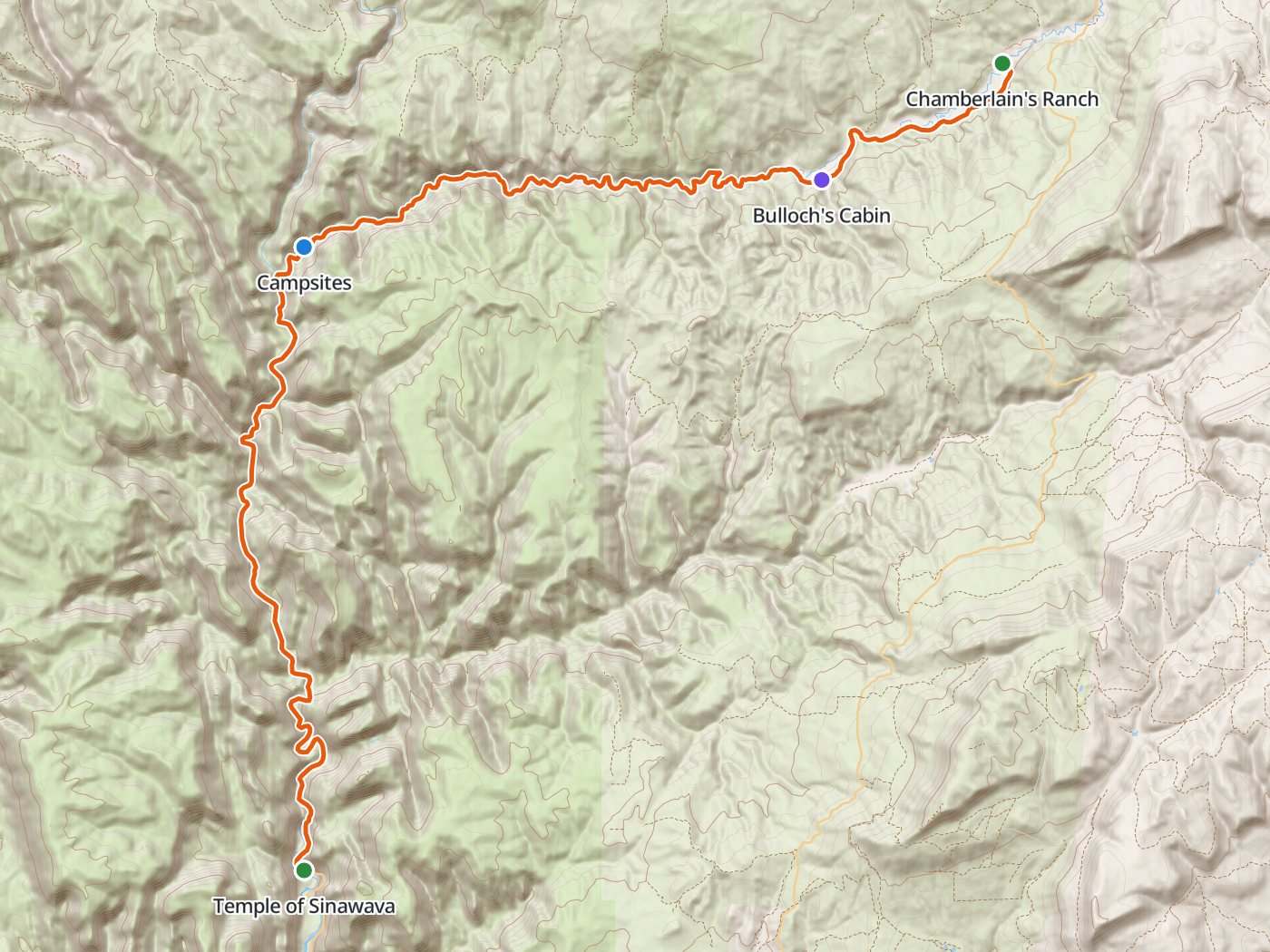
The route down the North Fork, with the campsite area about halfway. Map data © OpenStreetMap contributors, elevation from Copernicus GLO-30.
Take the plan with you
The same plan opens in Backpackers Friend as a ready-made trip, with both trailheads and the campsite area already placed. The campsite point marks the stretch where the designated sites lie, so move the camp onto the site named on your permit. On a computer, scan the code with your phone's camera. On a phone, tap the button instead. With Premium, download the map before you leave, since the canyon has no signal. The GPX file carries the same route and waypoints for any other mapping tool.
The GPX route comes from OpenStreetMap data under the Open Database License.
The one-night plan, top down
The park describes the route in hours rather than miles, so the mileages here are measured along the river line and scaled to the park's 16 miles. The campsites lie roughly halfway, so the split point is an estimate. A 30-meter elevation model cannot separate the river from the canyon walls, so this guide leaves out climbing figures.
| Day | Route | Miles |
|---|---|---|
| 1 | Chamberlain's Ranch trailhead to Designated campsites (about halfway) | 8.5 |
| 2 | Designated campsites (about halfway) to Temple of Sinawava | 7.5 |
Day 1. Chamberlain's Ranch to the campsites, about 8.5 miles
The route leaves Chamberlain's Ranch on an old road along the river and passes Bulloch's Cabin about an hour in. The park's timetable places the First Narrows about three and a half hours from the start, a waterfall soon after, and the confluence with Deep Creek about five hours in. The twelve designated campsites lie roughly halfway down the route. Camp only at the site named on your permit, and remember that travel upstream to reach a campsite is not allowed.
Day 2. The campsites to the Temple of Sinawava, about 7.5 miles
The second day passes Kolob Creek and Goose Creek and reaches Big Spring, then enters the deepest and narrowest part of the canyon, where the river can run deep enough to swim. Orderville Canyon joins from the east, and below the junction the river fills with day hikers walking up from the bottom. The route ends at the north end of the paved Riverside Walk and the Temple of Sinawava, shuttle stop 9. Check the last shuttle time out of the canyon before you start.
Permits
- Every top-down trip needs a wilderness permit, whether done in one day or with one night of camping. Multi-night trips are not allowed in the Narrows.
- Reservations open on the 5th of each month at 10:00 AM Mountain Time on Recreation.gov, and most spaces fill within minutes. Reservations can be made until 5:00 PM Mountain Time the day before the trip.
- Convert the reservation into a permit at the Wilderness Desk the day before or the day of the trip.
- Fees are a $20 permit fee plus $7 per person per night.
- Campsite group limits vary, from two people at the smallest site to twelve at the largest, and a few sites are held for walk-up permits.
Closures and hazards
- Flow. The park closes all top-down trips when the Virgin River runs above 120 cubic feet per second, which often happens during spring snowmelt in April and May.
- Flash floods. The Narrows closes whenever the National Weather Service issues a flash flood warning and stays closed for at least two hours after the warning lifts. Warnings are common from July through September.
- Cold water. The park calls flash flooding and hypothermia constant dangers, with swift, cold water, slippery rock, and sections deep enough to swim.
- No permits during closures. The park does not issue permits while the canyon is closed.
Rules on the trail
- Pack out all human waste, toilet paper, and hygiene products. Each permit group must carry at least one human waste disposal bag per person.
- Camp only at designated campsites, and only at the site named on your permit.
- Pets are not allowed.
Getting to the trailheads
Chamberlain's Ranch sits outside the park, east of Zion Canyon, and the park requires hikers to arrange their own transportation to the trailhead. Several local outfitters run shuttles. The route ends at the Temple of Sinawava, which the park shuttle serves during shuttle season.
Water
The river runs beside you the whole way, but the park warns about cyanobacteria in the Virgin River, so carry treated water from the trailhead or a reliable spring and follow the park's current water advisories.
Questions people ask
How long is the top-down Zion Narrows hike?
The park describes the top-down Narrows as 16 miles from Chamberlain's Ranch to the Temple of Sinawava, taking 10 to 14 hours, which many hikers split over two days with an overnight permit.
Can you camp in the Zion Narrows?
Yes, for one night only, at one of the twelve designated campsites roughly halfway down the route, with an overnight permit for a top-down trip.
How do you get a Zion Narrows overnight permit?
Reserve on Recreation.gov, where the calendar opens on the 5th of each month at 10:00 AM Mountain Time, then convert the reservation at the Wilderness Desk the day before or the day of the trip.
When does the Zion Narrows close?
Top-down trips close when the Virgin River runs above 120 cubic feet per second and whenever a flash flood warning is in effect, staying closed for at least two hours after a warning lifts.
Do you need a waste bag in the Zion Narrows?
Yes. Human waste must be packed out of the Narrows, and each permit group must carry at least one human waste disposal bag per person.
Sources
The route, timetable, campsite rules, flow limit, and hazards come from Zion's Narrows from the top down page and Narrows page. The reservation calendar comes from the park's Narrows permits page, campsite group limits from the park's Narrows campsites page, the waste bag rule from the park's Narrows regulations, and fees from the Recreation.gov overnight Narrows listing. Conditions in the canyon change by the hour, so confirm each rule with the park before you go.
Plan the trip, then walk the plan
Backpackers Friend opens this plan as a trip on your phone, snaps the route to the trail, and lays the days out on a topo map. Planning is free with no account. Premium adds offline maps so the whole route works in airplane mode, plus off-trail alerts if you drift from the line.
