
Lost Coast Trail Itinerary, Day by Day
The Lost Coast is the longest stretch of California shoreline that no highway reaches. The northern Lost Coast Trail follows the beach and the low marine terraces for 24.6 miles from the mouth of the Mattole River to Black Sands Beach at Shelter Cove, below mountains that rise straight out of the sea. Three stretches flood at high tide, so the walk runs on the tide table rather than the clock. The plan below covers the trail in three days, the minimum the Bureau of Land Management recommends.
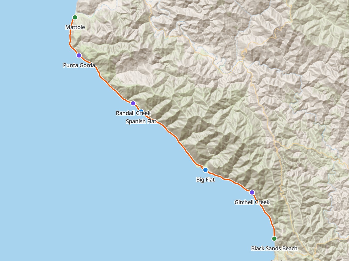
The route from north to south, with the two camps of the plan below. Map data © OpenStreetMap contributors, elevation from Copernicus GLO-30.
Take the plan with you
The same two-night plan opens in Backpackers Friend as a ready-made trip, with both camps and both trailheads already placed, and the app routes between them along the trail. On a computer, scan the code with your phone's camera. On a phone, tap the button instead. With Premium, download the map before you leave and the route works in airplane mode. The GPX file carries the same route and waypoints for any other mapping tool.
The GPX route comes from OpenStreetMap data under the Open Database License.
The two-night plan, north to south
Mileages are measured along the trail line and scaled to the Bureau of Land Management's 24.6 miles. The trail stays near sea level, and the elevation model cannot separate the beach from the cliffs above, so this guide leaves out climbing figures.
| Day | Route | Miles |
|---|---|---|
| 1 | Mattole trailhead to Spanish Flat | 9.9 |
| 2 | Spanish Flat to Big Flat | 6.8 |
| 3 | Big Flat to Black Sands Beach | 7.9 |
Day 1. Mattole to Spanish Flat, 9.9 miles
The trail leaves the Mattole River mouth and follows the beach south to the abandoned Punta Gorda Lighthouse near mile 3.2. The first tide zone lies near Punta Gorda, and the second runs from Sea Lion Gulch to Randall Creek, so check the tide table and time both for an outgoing tide of three feet or less. Spanish Flat, a broad marine terrace above the beach, sits just past Randall Creek near mile 9.9.
Day 2. Spanish Flat to Big Flat, 6.8 miles
The middle day follows the beach and the terraces south to Big Flat, a wide grassy flat at the mouth of Big Flat Creek. The short day leaves room to wait out a high tide on the third morning.
Day 3. Big Flat to Black Sands Beach, 7.9 miles
The third tide zone, from Miller Flat to Gitchell Creek, comes on the last day, so plan the start around the morning tide. Past Gitchell Creek the trail continues to Black Sands Beach at Shelter Cove. The Bureau of Land Management allows camping only north of Telegraph Creek and not at the Black Sands Beach trailhead, so finish the walk rather than camp near the end.
Three nights for a slower walk
Three nights add a first camp near Cooskie Creek, which shortens the first day and gives more room to time the tide zones.
| Day | Route | Miles |
|---|---|---|
| 1 | Mattole trailhead to Cooskie Creek | 6.6 |
| 2 | Cooskie Creek to Spanish Flat | 3.3 |
| 3 | Spanish Flat to Big Flat | 6.8 |
| 4 | Big Flat to Black Sands Beach | 7.9 |
The tide zones
The Bureau of Land Management names three stretches that may be impassable at high tide. One lies near Punta Gorda, one runs from Sea Lion Gulch to Randall Creek, and one runs from Miller Flat to Gitchell Creek. Carry a tide table and walk each zone on an outgoing tide of three feet or less. Recreation.gov publishes the dates each season when the tides leave the route impassable, so check the calendar before you choose your dates. Our own February 2022 trip report covers what walking the route around the tides felt like on the ground.
Permits
- Overnight trips need a King Range wilderness permit from Recreation.gov. Day hikes need none.
- Reservations open on a rolling 90-day window at 7:00 AM Pacific, and each person may hold one active permit at a time.
- The fee is $6 per permit.
- Daily capacity was 60 people a day from May 15 to September 15 and 30 people a day the rest of the year in the agency's 2025 fact sheet. Groups are limited to 15 people.
- Walk-up permits for up to three hikers are sold at the King Range Visitor Center, Monday through Saturday from 8:00 AM to 4:30 PM, from May 30 to September 5.
Rules on the trail
- Carry a hard-sided bear canister for every person. Bags are not allowed, and canisters rent for $5 a trip.
- Camp only north of Telegraph Creek, and never at the Black Sands Beach trailhead.
- Stay off private property along the route, and wear sturdy boots for long miles on sand and cobble.
Getting to the trailheads
The Mattole trailhead sits at the Mattole Recreation Site at the mouth of the Mattole River, and Black Sands Beach sits at Shelter Cove. The Bureau of Land Management puts the drive between them at about two hours, so leave a car at one end and arrange a shuttle to the other before you start.
Water
The Bureau of Land Management describes water as plentiful along the beach, from the creeks that cross the route. Treat all of the water.
Questions people ask
How long is the Lost Coast Trail?
The northern Lost Coast Trail runs 24.6 miles from the Mattole River to Black Sands Beach at Shelter Cove. The Bureau of Land Management recommends allowing at least three days.
Where are the tide zones on the Lost Coast Trail?
The Bureau of Land Management names three stretches that may be impassable at high tide, near Punta Gorda, from Sea Lion Gulch to Randall Creek, and from Miller Flat to Gitchell Creek. Walk each one on an outgoing tide of three feet or less.
Do you need a permit for the Lost Coast Trail?
Overnight trips need a King Range wilderness permit from Recreation.gov, where reservations open on a rolling 90-day window. Walk-up permits for up to three hikers are sold at the King Range Visitor Center in summer.
Do you need a bear canister on the Lost Coast?
Yes. Hard-sided bear canisters are required, one per person, and bags are not allowed.
Which direction should you hike the Lost Coast Trail?
This plan walks north to south from Mattole to Black Sands Beach, the direction the agency lists the trail. Either direction works as long as the tide zones are timed to an outgoing tide.
Sources
Distance, the tide zones, camping limits, walk-up permits, and drive times come from the Bureau of Land Management's Lost Coast Trail page, the permit fee and group size from the agency's King Range permits page, and daily capacity from the agency's 2025 King Range fact sheet. The reservation window, canister rule, and tide calendar come from the Recreation.gov permit listing. Rules change between seasons, so confirm each one with the agency before you go.
Plan the trip, then walk the plan
Backpackers Friend opens this plan as a trip on your phone, snaps the route to the trail, and lays the days out on a topo map. Planning is free with no account. Premium adds offline maps so the whole route works in airplane mode, plus off-trail alerts if you drift from the line.
