
Minarets Loop Itinerary, Day by Day
The Minarets are a saw-toothed ridge of dark volcanic spires west of Mammoth Lakes, beside Mount Ritter and Banner Peak, and two lakes sit directly beneath them. Ediza Lake lies at the head of Shadow Creek below Mount Ritter, and Minaret Lake lies at the head of Minaret Creek below Clyde Minaret. The plan below visits both on maintained trails, starting at Agnew Meadows and finishing at Reds Meadow, which the valley shuttle links. A shorter and far rougher off-trail crossing joins the two lakes past Cecile Lake, and this guide does not route over the crossing.
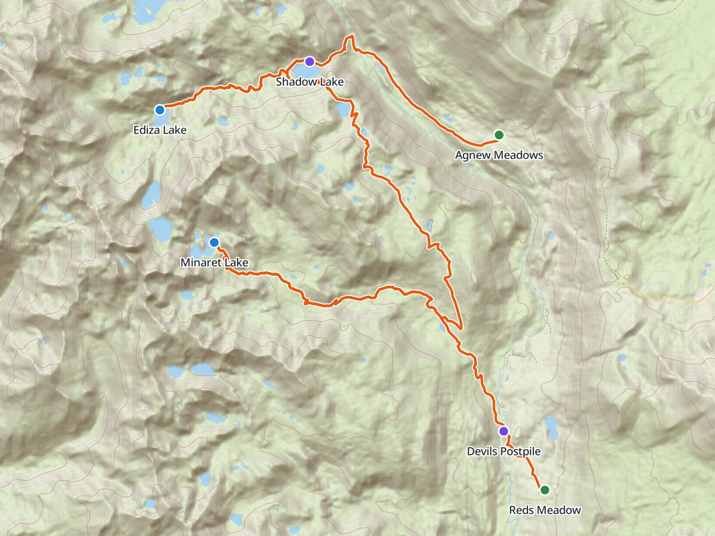
The maintained-trail route with the two camps of the plan below. Map data © OpenStreetMap contributors, elevation from Copernicus GLO-30.
Take the plan with you
The same two-night plan opens in Backpackers Friend as a ready-made trip, with both camps and both trailheads already placed, and the app routes between them along the trail. On a computer, scan the code with your phone's camera. On a phone, tap the button instead. With Premium, download the map before you leave and the route works in airplane mode. The GPX file carries the same route and waypoints for any other mapping tool.
The GPX route comes from OpenStreetMap data under the Open Database License.
The two-night plan on maintained trails
Mileages are measured along the trail line. Climbing and camp elevations come from a 30-meter elevation model sampled along the trail, so treat them as close estimates rather than survey numbers.
| Day | Route | Miles | Climb | Descent | Camp |
|---|---|---|---|---|---|
| 1 | Agnew Meadows trailhead to Ediza Lake | 6.4 | 1,500 ft | 550 ft | 9,300 ft |
| 2 | Ediza Lake to Minaret Lake | 13.9 | 2,850 ft | 2,300 ft | 9,900 ft |
| 3 | Minaret Lake to Reds Meadow | 7.9 | 300 ft | 2,450 ft |
Elevation along the route. Blue dots mark the camps at Ediza Lake and Minaret Lake.
Day 1. Agnew Meadows to Ediza Lake, 6.4 miles
The trail leaves Agnew Meadows, shuttle stop 1, and drops to the Middle Fork of the San Joaquin before climbing switchbacks to Shadow Lake at mile 3.7. Camping is closed at Shadow Lake and along the stretch between Shadow Creek and the trail. The Shadow Creek trail continues up the canyon to Ediza Lake below Mount Ritter and Banner Peak. Camping is closed within an eighth of a mile of the lake's south side, so look for a legal site elsewhere around the basin.
Day 2. Ediza Lake to Minaret Lake, 13.9 miles
The route returns down Shadow Creek to the John Muir Trail and heads south past Rosalie Lake at mile 11.3 to the junction at Johnston Meadow, mile 15.8. From the junction the Minaret Creek trail climbs about 1,700 feet to Minaret Lake at mile 20.3, directly beneath Clyde Minaret. Campfires are closed throughout the Minaret Lake area.
Day 3. Minaret Lake to Reds Meadow, 7.9 miles
The trail descends Minaret Creek back to Johnston Meadow and continues to Devils Postpile, a wall of columnar basalt in a small national monument, at mile 27.1. The Reds Meadow shuttle stop sits a mile beyond, at mile 28.2.
Three nights for shorter days
Three nights add a camp near Rosalie Lake on the John Muir Trail and split the long second day in two.
| Day | Route | Miles | Climb | Descent |
|---|---|---|---|---|
| 1 | Agnew Meadows trailhead to Ediza Lake | 6.4 | 1,500 ft | 550 ft |
| 2 | Ediza Lake to Rosalie Lake | 4.6 | 800 ft | 650 ft |
| 3 | Rosalie Lake to Minaret Lake | 9.3 | 2,050 ft | 1,650 ft |
| 4 | Minaret Lake to Reds Meadow | 7.9 | 300 ft | 2,450 ft |
The Cecile Lake crossing
A popular shortcut links Ediza Lake to Minaret Lake past Iceberg Lake and Cecile Lake, which cuts the route roughly in half. The crossing is not maintained trail. The ground above Iceberg Lake is steep and loose, snow can linger there into summer, and the descent to Minaret Lake needs careful route-finding. On our own September 2024 trip, the line a navigation app drew over that ridge turned out to be loose scree on a steep fall line, and we turned back on inspection. Treat the crossing as off-trail scrambling that suits experienced parties in good conditions, and plan the maintained route above as the default.
Permits
- Reserve an Inyo National Forest wilderness permit for the Shadow Creek trail on Recreation.gov. The trail allows 30 overnight visitors a day from May 1 to November 1.
- Reservations open in two blocks. Sixty percent of each trailhead's quota opens six months before the entry date, and the remaining 40 percent opens two weeks before entry at 7:00 AM Pacific.
- Fees are a $6 transaction fee per permit plus $5 per person.
- Print the permit at home up to seven days before the trip. The forest cancels unprinted overnight reservations at 10:00 AM on the entry date.
Rules on the trail
- Camping closures cover Shadow Lake, the stretch between Shadow Creek and the trail, and the area within an eighth of a mile of the south side of Ediza Lake.
- Campfires are closed from Shadow Lake through the Ediza, Iceberg, and Minaret Lake areas, and at any location above 10,000 feet.
- Store food from bears. Inyo allows a counterbalance hang where trees are suitable and requires a bear-resistant container where trees are not, which makes a canister the practical choice at these timberline lakes.
- Groups are limited to 15 people, day users included. Camp at least 100 feet from trails and water.
Getting to the trailheads
Agnew Meadows and Reds Meadow both sit on the Reds Meadow Road west of Mammoth Lakes. In a normal season the forest requires visitors to ride the shuttle from the Mammoth Mountain Adventure Center, which makes the point-to-point route easy, since both ends are shuttle stops. The road closes in winter, typically from mid-October to late June, and the 2026 reconstruction limits the open days further.
Water
Shadow Creek, Ediza Lake, the lakes along the John Muir Trail, and Minaret Creek supply water along the whole route. Treat all of the water.
Questions people ask
How long is the Minarets loop?
On maintained trails from Agnew Meadows to Ediza Lake and Minaret Lake and out to Reds Meadow, the route measures about 28.2 miles with roughly 4,650 feet of climbing.
Is the Cecile Lake route a trail?
No. The crossing from Iceberg Lake past Cecile Lake to Minaret Lake is off-trail scrambling over steep, loose ground that can hold snow into summer. This plan stays on maintained trails instead.
Can you camp at Shadow Lake?
No. Inyo National Forest closes Shadow Lake and the stretch between Shadow Creek and the trail to camping. Ediza Lake is the usual first camp, outside the closure that covers the lake's south side.
Do you need a permit for Ediza Lake?
Yes. Overnight trips need an Inyo National Forest wilderness permit, and the Shadow Creek trail allows 30 overnight visitors a day from May 1 to November 1.
How do you get to Agnew Meadows?
In a normal season the forest requires visitors to ride the Reds Meadow shuttle from the Mammoth Mountain Adventure Center. The Reds Meadow Road is being rebuilt, so check the current road and shuttle schedule first.
Sources
Camping closures, fire closures, food storage, and group size come from Inyo National Forest's wilderness regulations. The quota, shuttle, and winter closure come from the forest's Shadow Creek trail page, permit timing and fees from the forest's wilderness permits page, and the 2026 access limits from the forest's Reds Meadow Road page. Rules change between seasons, so confirm each one with the forest before you go.
Plan the trip, then walk the plan
Backpackers Friend opens this plan as a trip on your phone, snaps the route to the trail, and lays the days out on a topo map. Planning is free with no account. Premium adds offline maps so the whole route works in airplane mode, plus off-trail alerts if you drift from the line.
