
Wapama Falls and the Footbridges at High Water
Wapama Falls drops about 1,400 feet off the north wall of Hetch Hetchy and lands on a boulder field beside the reservoir, and the trail from O'Shaughnessy Dam crosses the bottom of the falls on a set of wooden footbridges. The walk out to the bridges and back is a short hike, about 5 miles round trip. In spring melt the same bridges carry water over the decks and through the cable rails, and the crossing becomes the most serious spot on the way to Rancheria Falls. We crossed in late April 2024 with the water running over the boards.
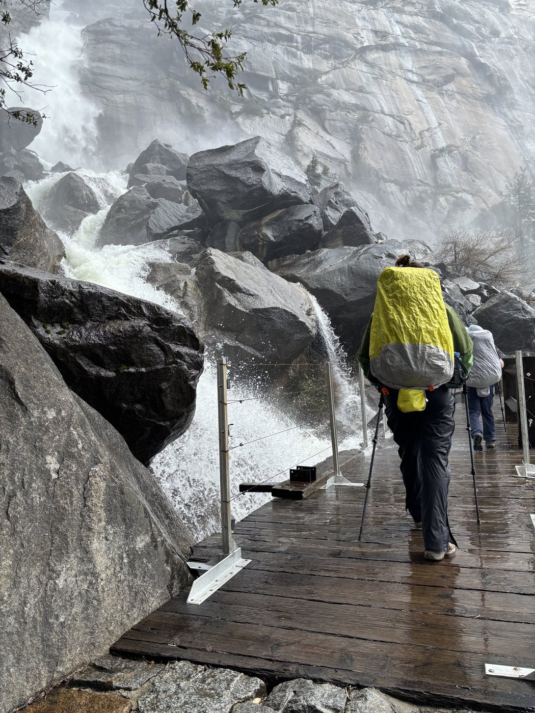
The Wapama footbridges on April 25, 2024, with the water coming over the deck and through the cable rail.
The hike from O'Shaughnessy Dam
- Distance. The park lists the hike to Wapama Falls as 5 miles round trip with 507 feet of climbing, about two hours.
- The route. Cross the top of O'Shaughnessy Dam, walk through the tunnel at the far end, and follow the trail north and east along the shore. Tueeulala Falls comes off the wall about two miles in, and the Wapama footbridges come about half a mile later. The trail rises and falls the whole way with moderate climbs.
- On the trail. The park warns of rattlesnakes and poison oak and asks hikers to carry plenty of water and sunscreen. Pets are not allowed on the dam or the trails, and swimming and boating are prohibited in the reservoir.
- Getting there. The Hetch Hetchy Road is open only from sunrise to sunset, and closes when snow is falling or forecast overnight. The permit and road guide covers the road, the parking, and the entrance fee.
When the falls run highest
Spring is the season for Yosemite's waterfalls, when most of the snow melts, and the park says runoff usually peaks in May or June. Wapama flows all year and peaks in May. Tueeulala Falls, half a mile to the west, runs only on snowmelt and dries up by early summer, so April and May are the months to see both falls together. The same months put the most water across the Wapama footbridges, and a big snow year or a storm on the snowpack raises the flow further still.
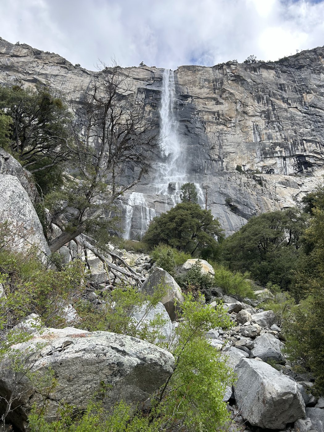
Tueeulala Falls in late April 2024, falling the full height of the wall in one ribbon.
High water at the bridges
The National Park Service documents bridge flooding during spring runoff and heavy rain, with two hikers killed in 2011 and one in 2017 after being swept off the bridges. Those events are recorded in the park's footbridge safety project. Conditions can change during an overnight trip beyond Wapama, so check the weather and reassess the crossing on the walk out. A planned bridge project does not establish that the work is complete or that a crossing is safe today.
Our crossing in April 2024
We crossed on the morning of April 25, 2024, on the way to Rancheria Falls. The rangers at the dam told us that morning that the falls were running strong, that the crossing was dangerous, and not to slip. At the bridges the water came over the decking and through the cable rails in sheets, the spray soaked everyone, and the noise made talking pointless. We went over one at a time and crossed again on the walk out the next morning in the rain. Those observations describe our trip on those dates. Water over the boards can make the bridge impassable, and our successful crossing cannot establish safe conditions for another hiker.
Questions people ask
How long is the hike to Wapama Falls?
The park lists the hike from O'Shaughnessy Dam as 5 miles round trip with 507 feet of climbing, about two hours. The trail crosses the dam, passes through a tunnel, and follows the north shore of Hetch Hetchy Reservoir past Tueeulala Falls.
When does Wapama Falls run highest?
Wapama flows all year and peaks in May, and spring is the season the park recommends for Yosemite's waterfalls. Tueeulala Falls, on the way, dries up by early summer, so April and May show both falls at once.
Is the Wapama Falls bridge safe?
Spring runoff and heavy rain can flood the Wapama footbridges. The National Park Service records fatal accidents at the bridges in 2011 and 2017. Ask rangers about current conditions, obey closures, and turn around before entering a flooded bridge. An earlier successful crossing does not establish safe conditions for the return walk.
Do you need a permit to hike to Wapama Falls?
A day hike needs no wilderness permit. The standard private-vehicle entrance fee is $35 for seven days, and additional nonresident fees may apply unless covered by an eligible pass. An overnight trip past Wapama to Rancheria Falls needs a wilderness permit for the Rancheria Falls trailhead.
Does Tueeulala Falls run in summer?
Tueeulala seldom runs in summer. The fall runs on snowmelt and dries up by early summer, so a summer visitor sees a dark streak on the granite where the fall comes down in spring.
Plan the rest of the trip
The Rancheria Falls guide continues past Wapama to the camp at Rancheria Creek, 6.5 miles from the dam, with a free GPX. The permit and road guide covers the wilderness permit and the Hetch Hetchy Road, and the trip story The Water Was Running Over the Bridge tells the whole April 2024 walk.
Sources
The distance, climbing, and time come from Yosemite's Wapama and Rancheria Falls Trailhead page and Day Hikes in Hetch Hetchy, which also give the mist warning and the trail hazards. Wapama's height, the peak in May, and the seasons of Yosemite's waterfalls come from the park's waterfalls page. Tueeulala's season comes from the San Francisco Public Utilities Commission, which runs the reservoir. The road hours, pets, and reservoir rules come from the park's Hetch Hetchy page, and the entrance fee from the fees page. Bridge flooding and deaths in 2011 and 2017 are documented in the National Park Service's Wapama footbridge safety project. Check the current conditions page for closures. Road, permit, campground, and park rules were reviewed October 22, 2026. Our own crossing comes from the April 2024 trip.
Know where you are past the bridges
Backpackers Friend opens the Rancheria Falls plan as a trip on your phone, with Tueeulala, Wapama, and the camp placed on a topo map. Planning is free with no account. Hetch Hetchy has no cell service, and Premium adds offline maps so the route and your position keep working without a signal.