Rancheria Falls Backpacking Guide, Hetch Hetchy
Rancheria Falls is a wide cascade of granite and white water at the east end of Hetch Hetchy Reservoir, in the quiet northwest corner of Yosemite. The trail starts on top of O'Shaughnessy Dam, passes through a tunnel in the rock, and follows the north shore of the reservoir past Tueeulala Falls and across the base of Wapama Falls on a set of footbridges. The park lists the round trip at 13 miles and says the walk works as a long day hike or an overnight. The plan below spends one night at the camp beside Rancheria Creek, with a two-night variation and the day hike. We walked the route in April 2024 with the waterfalls at full spring flow.
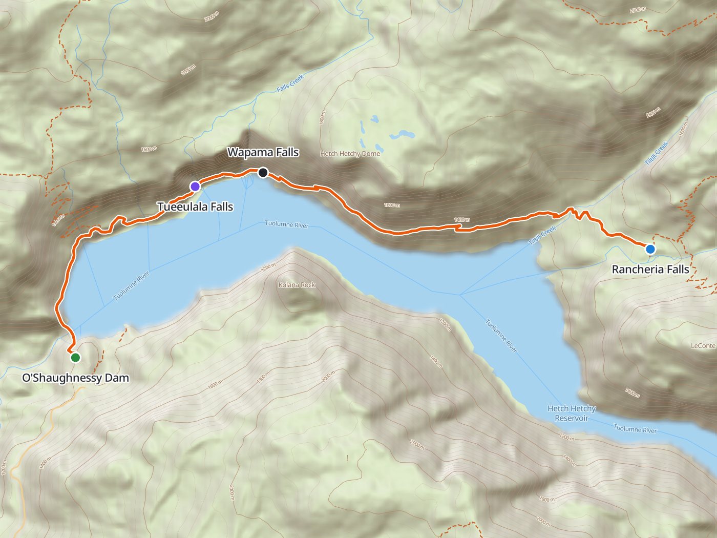
The route from O'Shaughnessy Dam along the north shore, with the camp at Rancheria Falls. Map data © OpenStreetMap contributors, elevation from Copernicus GLO-30.
Take the plan with you
The same plan opens in Backpackers Friend as a ready-made trip, with the dam, both waterfalls, and the camp already placed, and the app routes between them along the trail. On a computer, scan the code with your phone's camera. On a phone, tap the button instead. Hetch Hetchy has no cell service, so with Premium, download the map before you leave and the route works in airplane mode. The GPX file carries the same route and waypoints for any other mapping tool.
The GPX route comes from OpenStreetMap data under the Open Database License.
The one-night plan
Mileages follow the park's figure of 6.5 miles each way, scaled from the trail line. The trail stays between about 3,800 and 4,500 feet, but the line rises and falls over granite benches all the way, and the park counts 1,909 feet of climbing on the round trip. A 30-meter elevation model reads the cliffs beside the trail as climbing, so the table leaves climb out rather than print an inflated number.
| Day | Route | Miles |
|---|---|---|
| 1 | O'Shaughnessy Dam to Rancheria Falls | 6.5 |
| 2 | Rancheria Falls to O'Shaughnessy Dam | 6.5 |
Day 1. O'Shaughnessy Dam to Rancheria Falls, 6.5 miles
The walk begins by crossing the top of O'Shaughnessy Dam, with the reservoir on one side and the spillway gorge on the other, and goes straight into a lit tunnel through the rock. Past the tunnel the trail runs north and east along the shore, rising and falling over open granite. Tueeulala Falls drops off the wall about two miles in, and Wapama Falls comes down onto the boulder field about 2.5 miles from the dam, where the trail crosses the base of the falls on a series of footbridges. In spring the water can run across the decks. Beyond Wapama the trail climbs over benches above the water, and the park warns of rattlesnakes and poison oak along this stretch. Yosemite requires camping at least four trail miles from Hetch Hetchy, so the first legal ground lies well past Wapama. The camp at Rancheria Falls is a large flat area right beside the trail on the north side of Rancheria Creek, and the falls sheet across bare granite a short walk away.
Day 2. Rancheria Falls to O'Shaughnessy Dam, 6.5 miles
The walk out retraces the shore, with Kolana Rock across the water the whole way and the Wapama footbridges about four miles from camp. The road from Hetch Hetchy closes at sunset, so leave camp early enough to reach the car and drive out in daylight. Carry plenty of water and sunscreen on a warm day, since the north shore faces south into the sun.
Two nights for a full day at the falls
Two nights at Rancheria Falls leave a whole day to wander the slabs above and below the falls. The Rancheria Falls permit also covers camping in Tiltill Valley, north of the falls.
| Day | Route | Miles |
|---|---|---|
| 1 | O'Shaughnessy Dam to Rancheria Falls | 6.5 |
| 2 | A full day at Rancheria Falls | 0.0 |
| 3 | Rancheria Falls to O'Shaughnessy Dam | 6.5 |
Permits
- Reserve a wilderness permit for the Rancheria Falls trailhead. The park sets a daily quota of 35 for that trailhead. Twenty-one places go out by weekly lottery 24 weeks before the start date, and 14 open on Recreation.gov seven days ahead at 7:00 AM Pacific time.
- Fees are $10 to enter the lottery or make a reservation, plus $5 per person on a confirmed permit.
- Pick up at Big Oak Flat in season. From about April through October, Hetch Hetchy permits come from the Big Oak Flat Information Station, just inside the Big Oak Flat Entrance on Highway 120, during open hours. The park gives 8:00 AM to 5:00 PM for the wilderness centers and issues no permits after hours. A permit not picked up by 11:00 AM on the start date is cancelled unless you request a late-arrival hold.
- Self-register in winter. From November through March, permits need no reservation and come from the rear window of the Hetch Hetchy Entrance Station kiosk. We walked in on April 25, 2024, before the reservation season opened, and picked up a walk-up permit.
The Rancheria Falls permit and Hetch Hetchy Road guide covers the lottery, the pickup, and parking step by step.
The Wapama Falls footbridges
Wapama Falls drops about 1,400 feet and peaks in May. Spring runoff and heavy rain can flood the footbridges. The National Park Service records two deaths in 2011 and one in 2017 after hikers were swept off the bridges. Ask rangers about the crossing before leaving the dam, obey closures, and turn around before entering a flooded bridge. Conditions can change before the return walk from Rancheria Falls. Our April 2024 crossing is a dated observation, and cannot establish whether another crossing is safe. The Wapama Falls guide covers the crossing and day hike.
Rules on the trail
- Carry a bear canister. Yosemite requires canisters throughout the wilderness, prohibits hanging food, and does not allow bear spray. We found no food lockers at the Rancheria Falls camp in 2024. Bring an approved canister, or confirm rentals at an open wilderness center. After the wilderness centers close for the season, rentals are available at the Yosemite Valley Welcome Center.
- Camp at least four trail miles from Hetch Hetchy, at least one mile from any road, and at least 100 feet from water and the trail.
- Check current fire restrictions. When no additional restriction applies, fires are allowed only in existing fire rings below 9,600 feet and at least 100 feet from water and the trail.
- Keep the reservoir clean. Hetch Hetchy supplies San Francisco's drinking water, so swimming and boating in the reservoir are prohibited. Public access below the reservoir high-water mark is prohibited, and the park asks for all washing and human waste disposal to happen 300 feet from water within the reservoir's high-water mark.
- No pets on the dam or the trails, and groups are limited to 15 people.
Getting to Hetch Hetchy
The Hetch Hetchy Road leaves Highway 120 just outside the Big Oak Flat Entrance and runs to the dam, with an entrance station on the way. The road is open only from sunrise to sunset, closes when snow is falling or forecast overnight, and may require chains or close from November through March. Vehicles or trailers longer than 25 feet or wider than 8 feet are not allowed. The standard private-vehicle entrance fee is $35 for seven days. Additional nonresident fees may apply unless covered by an eligible pass. Check the park's current fees before travel. Yosemite requires no timed-entry reservation in 2026. Backpackers with a permit leave the car in the overnight lot near the dam, and the backpackers campground beside that lot takes permit holders the night before and the night after a trip for $8 per person. We drove from Sacramento in about three and a half hours, charged the car in Groveland on the way, and slept at the backpackers campground the night before.
When to go
Hetch Hetchy sits at about 3,900 feet and has one of the longest hiking seasons in the park. Spring is the season for the waterfalls and wildflowers. Tueeulala Falls runs on snowmelt and dries up by early summer, and Wapama Falls flows all year with a peak in May, which is also when the footbridges run wettest. Wilderness permit reservations apply from April 24 to October 18 in 2026, and permits are first come, first served outside those dates. In late April 2024 we met no mosquitoes, no ticks, no heat, and no snow, and rain arrived on the walk out.
Water
Water is plentiful in spring. Small cascades cross the trail along the north shore, Falls Creek runs under the Wapama footbridges, and Rancheria Creek runs beside the camp. Several of the side streams fade by late summer, so carry more from Wapama on a hot day. Treat all of the water. We used a Katadyn BeFree filter at Rancheria Creek.
Day hike or overnight
The park lists Rancheria Falls as a 13.4-mile round trip from the dam that takes 6 to 8 hours, which a fit hiker can walk in a day between sunrise and sunset. Wapama Falls alone is a 5-mile round trip of about two hours. An overnight trades the rush against the road hours for an afternoon at the falls and the morning light on Kolana Rock.
Our trip in April 2024
Three of us drove in on Wednesday, April 24, 2024, and slept at the backpackers campground by the dam. We crossed the dam at nine the next morning and reached Rancheria Falls in the early afternoon, with every gully on the north wall running. The camp was the large flat beside the trail on the north side of Rancheria Creek, and two other groups were there. Rain came on Friday, and we walked out in the rain under a rainbow over the reservoir. The full account is in the trip story, The Water Was Running Over the Bridge.
Questions people ask
How long is the hike to Rancheria Falls?
The park lists the round trip from O'Shaughnessy Dam at 13 to 13.4 miles, or about 6.5 miles each way, with 1,909 feet of climbing. Wapama Falls, the usual turnaround for a short hike, is a 5-mile round trip.
Do you need a permit to backpack to Rancheria Falls?
Yes. Every overnight trip in Yosemite needs a wilderness permit. Reserve one for the Rancheria Falls trailhead on Recreation.gov from late April through mid-October, by the lottery 24 weeks ahead or the release seven days ahead. A day hike needs no permit.
Where do you pick up a Hetch Hetchy wilderness permit?
From about April through October, at the Big Oak Flat Information Station just inside the Big Oak Flat Entrance on Highway 120, during open hours. From November through March, self-register at the rear window of the Hetch Hetchy Entrance Station kiosk.
What are the Hetch Hetchy Road hours?
The road is open only from sunrise to sunset. The road closes when snow is falling or forecast overnight and may require chains from November through March. Call 209-372-0200 for current conditions.
Is the Wapama Falls bridge safe to cross?
Spring runoff and heavy rain can flood the Wapama footbridges. The National Park Service records fatal accidents at the bridges in 2011 and 2017. Ask rangers about current conditions, obey closures, and turn around before entering a flooded bridge. An earlier successful crossing does not establish safe conditions for the return walk.
Where do you camp at Rancheria Falls?
At the large camp beside the trail on the north side of Rancheria Creek, about 6.5 miles from the dam, with a wilderness permit for the Rancheria Falls trailhead. We found no food lockers at the camp in April 2024, so carry a bear canister. The same permit also covers camping in Tiltill Valley.
Sources
Distances, times, and hazards come from Yosemite's Day Hikes in Hetch Hetchy and Wapama and Rancheria Falls Trailhead pages, and the road hours, vehicle limits, and reservoir rules from the park's Hetch Hetchy page and current conditions. Quotas come from the trailhead list, the lottery and fees from the wilderness permits page and Recreation.gov, the pickup locations from the permit stations page, and camping, fire, and food rules from the wilderness regulations. The backpackers campground comes from the park's backpackers campgrounds page, Wapama's height and peak from the waterfalls page, and Tueeulala's season from the San Francisco Public Utilities Commission. Bridge flooding and the fatal accidents in 2011 and 2017 are documented in the National Park Service's Wapama footbridge safety project. Current pickup and rental information comes from wilderness conditions, and entrance charges from the fees page. Road, permit, campground, and park rules were reviewed October 22, 2026. Rules change between seasons, so confirm each one with the park before you go.
Plan the trip, then walk the plan
Backpackers Friend opens this plan as a trip on your phone, snaps the route to the trail, and lays the days out on a topo map. Planning is free with no account. Premium adds offline maps so the whole route works in airplane mode, plus off-trail alerts if you drift from the line.