
Tahoe Rim Trail Itinerary, Day by Day
The Tahoe Rim Trail circles Lake Tahoe in 165 miles, following the high Carson Range on the Nevada side and the Sierra crest on the California side, with the lake in view for much of the way. The plan below walks the loop clockwise from Brockway Summit in fourteen days, using the camps from our own July 2026 thru-hike, with town nights where the trail drops to a road and a resupply. Clockwise front-loads the big Carson Range climbs while your legs are fresh and saves Desolation Wilderness for the second half.
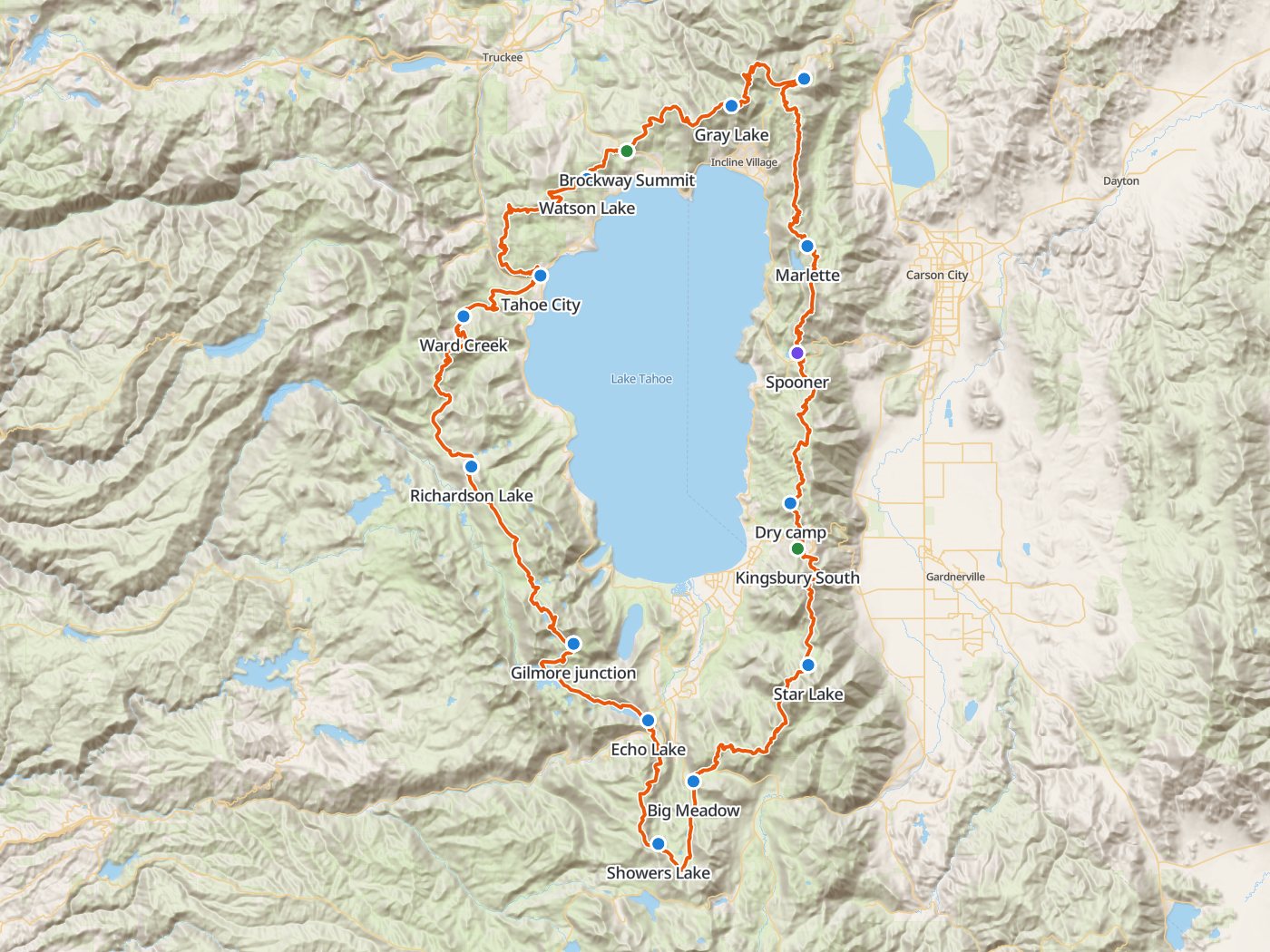
The clockwise loop with the camps and town nights of the plan below. Map data © OpenStreetMap contributors, elevation from Copernicus GLO-30.
Take the plan with you
The same plan opens in Backpackers Friend as a ready-made trip, with every camp and town stop already placed and the route drawn from the official Tahoe Rim Trail track. On a computer, scan the code with your phone's camera. On a phone, tap the button instead. With Premium, download the map before you leave and the loop works in airplane mode. The GPX file carries the same route and waypoints for any other mapping tool.
The GPX route comes from OpenStreetMap data under the Open Database License.
The thirteen-night plan, clockwise
Mileages are measured along the official Tahoe Rim Trail track and scaled to the published 165 miles. Climbing and camp elevations come from a 30-meter elevation model, so treat them as close estimates rather than survey numbers.
| Day | Route | Miles | Climb | Descent | Camp |
|---|---|---|---|---|---|
| 1 | Brockway Summit to Gray Lake | 9.8 | 2,750 ft | 500 ft | 9,300 ft |
| 2 | Gray Lake to Mount Rose Campground | 8.8 | 1,600 ft | 2,000 ft | 8,900 ft |
| 3 | Mount Rose Campground to Marlette Peak Campground | 14.1 | 1,900 ft | 2,350 ft | 8,400 ft |
| 4 | Marlette Peak Campground to Dry camp south of Spooner | 20.8 | 3,100 ft | 3,750 ft | 7,800 ft |
| 5 | Dry camp to Star Lake, resupply at Kingsbury South | 13.7 | 3,150 ft | 1,800 ft | 9,100 ft |
| 6 | Star Lake to Big Meadow basin | 13.9 | 1,950 ft | 3,800 ft | 7,300 ft |
| 7 | Big Meadow basin to Showers Lake | 7.5 | 1,850 ft | 500 ft | 8,700 ft |
| 8 | Showers Lake to Echo Lake (resupply night) | 9.9 | 1,200 ft | 2,450 ft | 7,400 ft |
| 9 | Echo Lake (resupply night) to Camp near the Gilmore Lake junction | 10.6 | 2,050 ft | 1,150 ft | 8,400 ft |
| 10 | Camp near the Gilmore Lake junction to Richardson Lake | 14.6 | 2,050 ft | 2,950 ft | 7,400 ft |
| 11 | Richardson Lake to Ward Creek | 14.9 | 2,350 ft | 3,000 ft | 6,800 ft |
| 12 | Ward Creek to Tahoe City (town night) | 7.0 | 550 ft | 1,100 ft | 6,200 ft |
| 13 | Tahoe City (town night) to Watson Lake | 16.0 | 3,000 ft | 2,150 ft | 7,000 ft |
| 14 | Watson Lake to Brockway Summit (finish) | 3.4 | 650 ft | 650 ft |
Elevation around the loop. Blue dots mark the camps and town nights.
Day 1. Brockway Summit to Gray Lake, 9.8 miles
The trail climbs about 2,750 feet from Brockway Summit onto the high ridge above the north shore, more climbing than any other day of the trip. Gray Lake sits on a short detour off the ridge, with reliable water and sheltered camps.
Day 2. Gray Lake over Relay Peak to Mount Rose Campground, 8.8 miles
The trail crosses Relay Peak, near 10,300 feet the highest point on the loop, and descends past Galena Falls to the Mount Rose Campground, which has potable water on tap.
Day 3. Mount Rose Campground to Marlette Peak Campground, 14.1 miles
The route crosses Tahoe Meadows and the Ophir Creek bridge and passes Chickadee Ridge, where hikers carry birdseed for the mountain chickadees, on the way to Marlette Peak Campground. Mountain bikes share the east side of the trail on even-numbered days.
Day 4. Marlette Peak Campground to a dry camp south of Spooner, 20.8 miles
The longest day passes Spooner Summit at mile 41.1, the last reliable water for nearly 20 miles. Load enough for the rest of the day, a dry night, and the morning, which came to six liters each on our trip, and dry-camp on the ridge south of Spooner.
Day 5. Dry camp to Star Lake, 13.7 miles
The trail descends to Kingsbury South, the resupply stop for Stateline and South Lake Tahoe, then climbs 9.4 miles and about 3,150 feet to Star Lake, one of the finest camps on the loop.
Day 6. Star Lake to the Big Meadow basin, 13.9 miles
The route crosses the high Freel Peak country, the wildest part of the loop, and descends to camps in the Big Meadow basin, past the trailhead itself.
Day 7. Big Meadow to Showers Lake, 7.5 miles
A short day crosses Round Lake and the open Meiss country to Showers Lake. Afternoon thunderstorms build over this exposed stretch in summer, and we watched one cross Meiss Meadow toward us.
Day 8. Showers Lake to Echo Lake, 9.9 miles
The trail descends to Echo Summit and Highway 50 through the old Caldor Fire burn, which has little shade. Camping is restricted from Highway 50 to the Desolation Wilderness boundary, so plan lodging or a legal site near Echo ahead of time. The Echo Lake water taxi shortcuts about two miles across the lake.
Day 9. Echo Lake to camp near the Gilmore Lake junction, 10.6 miles
The trail enters Desolation Wilderness past Lake Aloha, where camping is prohibited, and climbs into the granite basins below Dicks Pass. The thru-hike permit allows two nights at most in Desolation and requires camping within 300 feet of the trail.
Day 10. Gilmore Lake junction over Dicks Pass to Richardson Lake, 14.6 miles
The route climbs over Dicks Pass, passes the Velma Lakes, and leaves Desolation at the wilderness's gentle northern edge near Richardson Lake.
Day 11. Richardson Lake to Ward Creek, 14.9 miles
The trail continues north along the Sierra crest on the west side of the lake to camps along Ward Creek.
Day 12. Ward Creek to Tahoe City, 7.0 miles
A short day descends to Tahoe City at the lake's outlet for a town night and a final resupply.
Day 13. Tahoe City to Watson Lake, 16.0 miles
The trail climbs out of Tahoe City along the north shore ridges to Watson Lake.
Day 14. Watson Lake to Brockway Summit, 3.4 miles
The last short stretch closes the loop at Brockway Summit.
Permits
- The Desolation Wilderness thru-hike permit is required for anyone walking the full loop in one continuous trip, and covers the Tahoe Rim Trail through Desolation. The zone allows ten thru-hikers a night, and the permit opened on Recreation.gov in spring 2026.
- Two nights at most in Desolation, camped within 300 feet of the trail, with no camping around Lake Aloha.
- A California campfire permit is required to use a stove, and the permit is free online.
Rules on the trail
- Carry a hard-sided bear canister. All food and scented items must be stored in one on the entire Tahoe Rim Trail system.
- Campfires are prohibited along the trail. In the Tahoe Basin, fires are allowed only in designated campgrounds when no fire restrictions are in effect.
- Camp 100 to 300 feet from the trail, at least 200 feet from water and 100 feet from other trails, and never at a trailhead.
- Groups in Desolation are limited to 12 people.
- Mountain bikes share parts of the east side on even-numbered days.
Water
The west side, the south, and Desolation run wet, with creeks and lakes nearly everywhere. The Carson Range on the east and north runs dry, and the carry from Spooner Summit to Kingsbury covers nearly 20 miles without reliable water. Our July 2026 conditions report lists what every source held that month. Treat all of the water.
Our walk of the loop
This plan follows the camps of our own clockwise thru-hike in July 2026, written up as a conditions report and four legs, Leg 1, Leg 2, Leg 3, and the finale. The stories cover the weather, the water, the burn scar, and what thirteen days on the trail cost.
Questions people ask
How long is the Tahoe Rim Trail?
The Tahoe Rim Trail is a 165-mile loop around Lake Tahoe through California and Nevada. Measured along the official track, the loop climbs about 27,800 feet.
How many days does the Tahoe Rim Trail take?
Most thru-hikers take ten to fifteen days. This plan walks the loop clockwise in fourteen days with two town nights, following the camps of a July 2026 thru-hike.
Do you need a permit to thru-hike the Tahoe Rim Trail?
Yes. Full-loop thru-hikers need the Desolation Wilderness thru-hike permit from Recreation.gov, which allows ten thru-hikers a night and two nights at most in Desolation. A free California campfire permit is also required to use a stove.
Do you need a bear canister on the Tahoe Rim Trail?
Yes. All food and scented items must be stored in a hard-sided bear canister on the entire Tahoe Rim Trail system.
What is the longest dry stretch on the Tahoe Rim Trail?
The carry from Spooner Summit to Kingsbury runs nearly 20 miles without reliable water, so load up at Spooner and plan a dry camp.
Sources
The thru-hike permit, Desolation limits, and Lake Aloha closure come from the Eldorado National Forest's Desolation Wilderness permits page. The bear canister rule, campfire rules, camping distances, and stove permit come from the Tahoe Rim Trail Association's permits and regulations page. Water, the Caldor burn, mountain bike days, the water taxi, and the camps come from our own July 2026 conditions report. Rules change between seasons, so confirm each one with the agencies before you go.
Plan the trip, then walk the plan
Backpackers Friend opens this plan as a trip on your phone, snaps the route to the trail, and lays the days out on a topo map. Planning is free with no account. Premium adds offline maps so the whole route works in airplane mode, plus off-trail alerts if you drift from the line.
